You are here: Home > Network List > TA - USArray Transportable Network (new EarthScope stations) Stations List
> Station B18K Kokolik River, AK, USA > Earthquake Result Viewer
B18K Kokolik River, AK, USA - Earthquake Result Viewer
| Earthquake location: |
Northern Molucca Sea |
| Earthquake latitude/longitude: |
0.4/126.3 |
| Earthquake time(UTC): |
2019/07/08 (189) 06:20:10 GMT |
| Earthquake Depth: |
10 km |
| Earthquake Magnitude: |
5.5 Mww |
| Earthquake Catalog/Contributor: |
NEIC PDE/us |
|
| Network: |
TA USArray Transportable Network (new EarthScope stations) |
| Station: |
B18K Kokolik River, AK, USA |
| Lat/Lon: |
69.36 N/161.80 W |
| Elevation: |
222 m |
|
| Distance: |
83.3 deg |
| Az: |
19.837 deg |
| Baz: |
253.179 deg |
| Ray Param: |
0.046286244 |
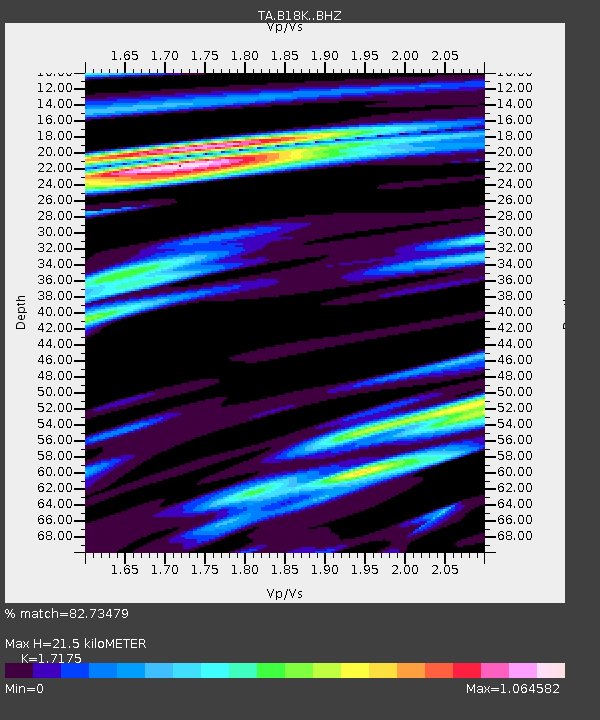
| Estimated Moho Depth: |
21.5 km |
| Estimated Crust Vp/Vs: |
1.72 |
| Assumed Crust Vp: |
5.906 km/s |
| Estimated Crust Vs: |
3.439 km/s |
| Estimated Crust Poisson's Ratio: |
0.24 |
|
| Radial Match: |
82.73479 % |
| Radial Bump: |
400 |
| Transverse Match: |
75.645966 % |
| Transverse Bump: |
400 |
| SOD ConfigId: |
19053131 |
| Insert Time: |
2019-07-22 06:23:18.150 +0000 |
| GWidth: |
2.5 |
| Max Bumps: |
400 |
| Tol: |
0.001 |
|
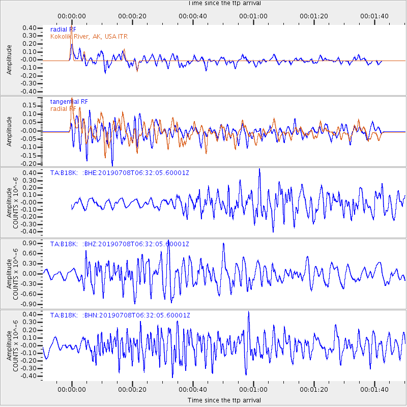
Signal To Noise
| Channel | StoN | STA | LTA |
| TA:B18K: :BHZ:20190708T06:32:05.60001Z | 2.6185539 | 2.3642387E-7 | 9.0287955E-8 |
| TA:B18K: :BHN:20190708T06:32:05.60001Z | 0.5750095 | 5.549013E-8 | 9.650297E-8 |
| TA:B18K: :BHE:20190708T06:32:05.60001Z | 1.0691545 | 4.979499E-8 | 4.6574176E-8 |
| Arrivals |
| Ps | 2.7 SECOND |
| PpPs | 9.7 SECOND |
| PsPs/PpSs | 12 SECOND |


