You are here: Home > Network List > TA - USArray Transportable Network (new EarthScope stations) Stations List
> Station C19K Lookout Ridge, AK, USA > Earthquake Result Viewer
C19K Lookout Ridge, AK, USA - Earthquake Result Viewer
| Earthquake location: |
Northern Molucca Sea |
| Earthquake latitude/longitude: |
0.4/126.3 |
| Earthquake time(UTC): |
2019/07/08 (189) 06:20:10 GMT |
| Earthquake Depth: |
10 km |
| Earthquake Magnitude: |
5.5 Mww |
| Earthquake Catalog/Contributor: |
NEIC PDE/us |
|
| Network: |
TA USArray Transportable Network (new EarthScope stations) |
| Station: |
C19K Lookout Ridge, AK, USA |
| Lat/Lon: |
69.10 N/159.59 W |
| Elevation: |
745 m |
|
| Distance: |
84.0 deg |
| Az: |
20.305 deg |
| Baz: |
255.299 deg |
| Ray Param: |
0.04579493 |
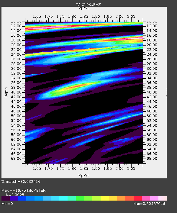
| Estimated Moho Depth: |
16.75 km |
| Estimated Crust Vp/Vs: |
2.09 |
| Assumed Crust Vp: |
6.221 km/s |
| Estimated Crust Vs: |
2.973 km/s |
| Estimated Crust Poisson's Ratio: |
0.35 |
|
| Radial Match: |
80.632416 % |
| Radial Bump: |
400 |
| Transverse Match: |
84.76977 % |
| Transverse Bump: |
400 |
| SOD ConfigId: |
19053131 |
| Insert Time: |
2019-07-22 06:23:19.887 +0000 |
| GWidth: |
2.5 |
| Max Bumps: |
400 |
| Tol: |
0.001 |
|

Signal To Noise
| Channel | StoN | STA | LTA |
| TA:C19K: :BHZ:20190708T06:32:09.124973Z | 4.8390856 | 2.6925315E-7 | 5.564133E-8 |
| TA:C19K: :BHN:20190708T06:32:09.124973Z | 1.3498625 | 4.7478068E-8 | 3.5172523E-8 |
| TA:C19K: :BHE:20190708T06:32:09.124973Z | 0.74155015 | 4.621562E-8 | 6.232299E-8 |
| Arrivals |
| Ps | 3.0 SECOND |
| PpPs | 8.2 SECOND |
| PsPs/PpSs | 11 SECOND |


