You are here: Home > Network List > TA - USArray Transportable Network (new EarthScope stations) Stations List
> Station N09A Rock Creek Ranch, Golconda, NV, USA > Earthquake Result Viewer
N09A Rock Creek Ranch, Golconda, NV, USA - Earthquake Result Viewer

| Earthquake location: |
Guatemala |
| Earthquake latitude/longitude: |
14.4/-91.0 |
| Earthquake time(UTC): |
2007/07/23 (204) 22:30:08 GMT |
| Earthquake Depth: |
113 km |
| Earthquake Magnitude: |
5.5 MW, 5.3 MB, 5.5 MW |
| Earthquake Catalog/Contributor: |
WHDF/NEIC |
|
| Network: |
TA USArray Transportable Network (new EarthScope stations) |
| Station: |
N09A Rock Creek Ranch, Golconda, NV, USA |
| Lat/Lon: |
40.85 N/117.52 W |
| Elevation: |
1617 m |
|
| Distance: |
35.1 deg |
| Az: |
323.823 deg |
| Baz: |
131.054 deg |
| Ray Param: |
0.07703802 |
| Estimated Moho Depth: |
33.5 km |
| Estimated Crust Vp/Vs: |
1.65 |
| Assumed Crust Vp: |
6.276 km/s |
| Estimated Crust Vs: |
3.792 km/s |
| Estimated Crust Poisson's Ratio: |
0.21 |
|
| Radial Match: |
87.225204 % |
| Radial Bump: |
400 |
| Transverse Match: |
69.797745 % |
| Transverse Bump: |
400 |
| SOD ConfigId: |
2564 |
| Insert Time: |
2010-03-07 01:21:46.343 +0000 |
| GWidth: |
2.5 |
| Max Bumps: |
400 |
| Tol: |
0.001 |
|
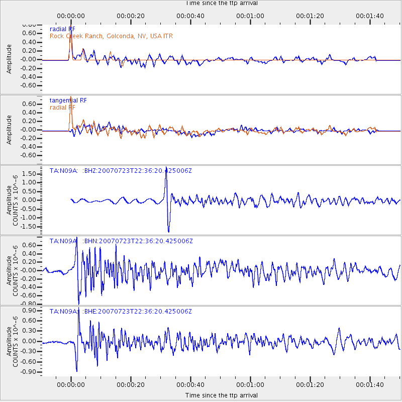
Signal To Noise
| Channel | StoN | STA | LTA |
| TA:N09A: :BHN:20070723T22:36:20.425006Z | 9.790897 | 3.7475738E-7 | 3.8276102E-8 |
| TA:N09A: :BHE:20070723T22:36:20.425006Z | 8.683715 | 3.5500585E-7 | 4.0881798E-8 |
| TA:N09A: :BHZ:20070723T22:36:20.425006Z | 9.293388 | 8.0515565E-7 | 8.663746E-8 |
| Arrivals |
| Ps | 3.8 SECOND |
| PpPs | 13 SECOND |
| PsPs/PpSs | 17 SECOND |


