You are here: Home > Network List > TA - USArray Transportable Network (new EarthScope stations) Stations List
> Station D17K Noatak River, AK, USA > Earthquake Result Viewer
D17K Noatak River, AK, USA - Earthquake Result Viewer
| Earthquake location: |
Irian Jaya, Indonesia |
| Earthquake latitude/longitude: |
-2.5/138.5 |
| Earthquake time(UTC): |
2019/07/08 (189) 06:55:57 GMT |
| Earthquake Depth: |
10 km |
| Earthquake Magnitude: |
5.6 mb |
| Earthquake Catalog/Contributor: |
NEIC PDE/us |
|
| Network: |
TA USArray Transportable Network (new EarthScope stations) |
| Station: |
D17K Noatak River, AK, USA |
| Lat/Lon: |
67.70 N/163.08 W |
| Elevation: |
172 m |
|
| Distance: |
80.8 deg |
| Az: |
19.226 deg |
| Baz: |
239.538 deg |
| Ray Param: |
0.048001956 |
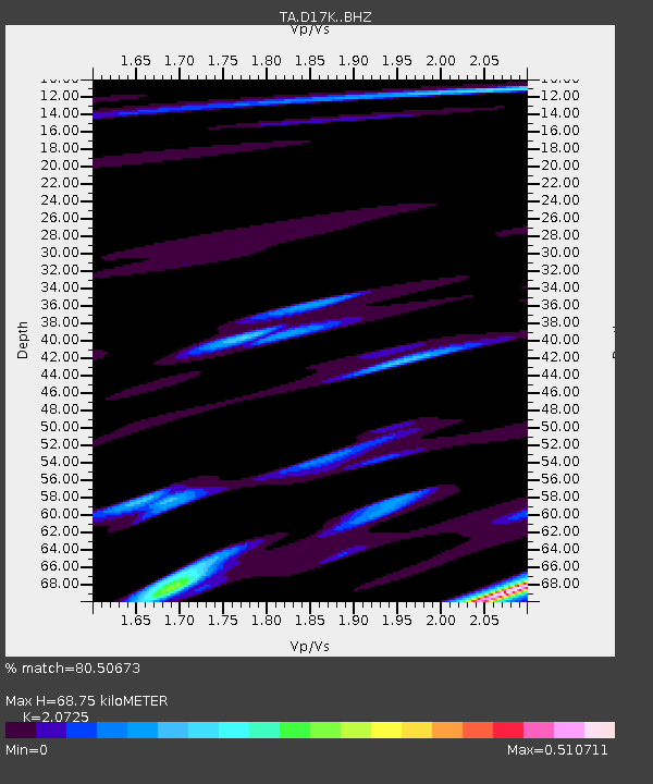
| Estimated Moho Depth: |
68.75 km |
| Estimated Crust Vp/Vs: |
2.07 |
| Assumed Crust Vp: |
6.276 km/s |
| Estimated Crust Vs: |
3.028 km/s |
| Estimated Crust Poisson's Ratio: |
0.35 |
|
| Radial Match: |
80.50673 % |
| Radial Bump: |
344 |
| Transverse Match: |
60.3096 % |
| Transverse Bump: |
400 |
| SOD ConfigId: |
19053131 |
| Insert Time: |
2019-07-22 06:59:40.696 +0000 |
| GWidth: |
2.5 |
| Max Bumps: |
400 |
| Tol: |
0.001 |
|

Signal To Noise
| Channel | StoN | STA | LTA |
| TA:D17K: :BHZ:20190708T07:07:40.425001Z | 4.7643557 | 2.8439675E-7 | 5.9692596E-8 |
| TA:D17K: :BHN:20190708T07:07:40.425001Z | 1.220103 | 5.5550974E-8 | 4.5529738E-8 |
| TA:D17K: :BHE:20190708T07:07:40.425001Z | 3.6683946 | 1.2512554E-7 | 3.410907E-8 |
| Arrivals |
| Ps | 12 SECOND |
| PpPs | 33 SECOND |
| PsPs/PpSs | 45 SECOND |


