You are here: Home > Network List > TA - USArray Transportable Network (new EarthScope stations) Stations List
> Station N09A Rock Creek Ranch, Golconda, NV, USA > Earthquake Result Viewer
N09A Rock Creek Ranch, Golconda, NV, USA - Earthquake Result Viewer
| Earthquake location: |
Mariana Islands |
| Earthquake latitude/longitude: |
21.0/144.7 |
| Earthquake time(UTC): |
2007/01/30 (030) 21:37:45 GMT |
| Earthquake Depth: |
30 km |
| Earthquake Magnitude: |
6.3 MB, 6.5 MS, 6.6 MW, 6.5 MW |
| Earthquake Catalog/Contributor: |
WHDF/NEIC |
|
| Network: |
TA USArray Transportable Network (new EarthScope stations) |
| Station: |
N09A Rock Creek Ranch, Golconda, NV, USA |
| Lat/Lon: |
40.85 N/117.52 W |
| Elevation: |
1617 m |
|
| Distance: |
82.2 deg |
| Az: |
49.344 deg |
| Baz: |
290.843 deg |
| Ray Param: |
0.047027007 |
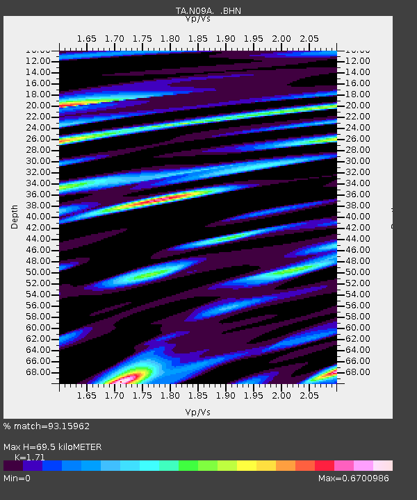
| Estimated Moho Depth: |
69.5 km |
| Estimated Crust Vp/Vs: |
1.71 |
| Assumed Crust Vp: |
6.276 km/s |
| Estimated Crust Vs: |
3.67 km/s |
| Estimated Crust Poisson's Ratio: |
0.24 |
|
| Radial Match: |
93.15962 % |
| Radial Bump: |
399 |
| Transverse Match: |
77.1519 % |
| Transverse Bump: |
400 |
| SOD ConfigId: |
2564 |
| Insert Time: |
2010-03-07 01:22:22.703 +0000 |
| GWidth: |
2.5 |
| Max Bumps: |
400 |
| Tol: |
0.001 |
|

Signal To Noise
| Channel | StoN | STA | LTA |
| TA:N09A: :BHN:20070130T21:49:32.650007Z | 1.9883307 | 3.0998427E-7 | 1.5590177E-7 |
| TA:N09A: :BHE:20070130T21:49:32.650007Z | 2.505985 | 6.5496897E-7 | 2.613619E-7 |
| TA:N09A: :BHZ:20070130T21:49:32.650007Z | 9.369921 | 1.6616385E-6 | 1.7733753E-7 |
| Arrivals |
| Ps | 8.1 SECOND |
| PpPs | 29 SECOND |
| PsPs/PpSs | 37 SECOND |


