You are here: Home > Network List > TA - USArray Transportable Network (new EarthScope stations) Stations List
> Station N09A Rock Creek Ranch, Golconda, NV, USA > Earthquake Result Viewer
N09A Rock Creek Ranch, Golconda, NV, USA - Earthquake Result Viewer
| Earthquake location: |
Rat Islands, Aleutian Islands |
| Earthquake latitude/longitude: |
52.2/176.2 |
| Earthquake time(UTC): |
2006/06/27 (178) 02:39:35 GMT |
| Earthquake Depth: |
34 km |
| Earthquake Magnitude: |
5.6 MB, 6.0 MS, 6.2 MW, 6.2 MW |
| Earthquake Catalog/Contributor: |
WHDF/NEIC |
|
| Network: |
TA USArray Transportable Network (new EarthScope stations) |
| Station: |
N09A Rock Creek Ranch, Golconda, NV, USA |
| Lat/Lon: |
40.85 N/117.52 W |
| Elevation: |
1617 m |
|
| Distance: |
45.5 deg |
| Az: |
76.981 deg |
| Baz: |
307.775 deg |
| Ray Param: |
0.07118762 |
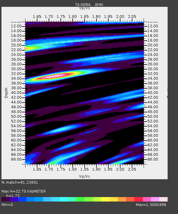
| Estimated Moho Depth: |
32.75 km |
| Estimated Crust Vp/Vs: |
1.72 |
| Assumed Crust Vp: |
6.276 km/s |
| Estimated Crust Vs: |
3.649 km/s |
| Estimated Crust Poisson's Ratio: |
0.24 |
|
| Radial Match: |
91.23901 % |
| Radial Bump: |
400 |
| Transverse Match: |
61.931084 % |
| Transverse Bump: |
400 |
| SOD ConfigId: |
2564 |
| Insert Time: |
2010-03-07 01:22:37.887 +0000 |
| GWidth: |
2.5 |
| Max Bumps: |
400 |
| Tol: |
0.001 |
|

Signal To Noise
| Channel | StoN | STA | LTA |
| TA:N09A: :BHN:20060627T02:47:20.650005Z | 2.5484452 | 1.5184963E-7 | 5.9585204E-8 |
| TA:N09A: :BHE:20060627T02:47:20.650005Z | 5.0880957 | 2.079652E-7 | 4.0872898E-8 |
| TA:N09A: :BHZ:20060627T02:47:20.650005Z | 5.136017 | 4.0572482E-7 | 7.8996E-8 |
| Arrivals |
| Ps | 4.0 SECOND |
| PpPs | 13 SECOND |
| PsPs/PpSs | 17 SECOND |


