You are here: Home > Network List > TA - USArray Transportable Network (new EarthScope stations) Stations List
> Station N09A Rock Creek Ranch, Golconda, NV, USA > Earthquake Result Viewer
N09A Rock Creek Ranch, Golconda, NV, USA - Earthquake Result Viewer
| Earthquake location: |
Vanuatu Islands |
| Earthquake latitude/longitude: |
-15.8/167.8 |
| Earthquake time(UTC): |
2006/08/07 (219) 22:18:54 GMT |
| Earthquake Depth: |
141 km |
| Earthquake Magnitude: |
6.0 MB, 6.8 MW, 6.8 MW |
| Earthquake Catalog/Contributor: |
WHDF/NEIC |
|
| Network: |
TA USArray Transportable Network (new EarthScope stations) |
| Station: |
N09A Rock Creek Ranch, Golconda, NV, USA |
| Lat/Lon: |
40.85 N/117.52 W |
| Elevation: |
1617 m |
|
| Distance: |
89.0 deg |
| Az: |
47.03 deg |
| Baz: |
248.234 deg |
| Ray Param: |
0.04184837 |
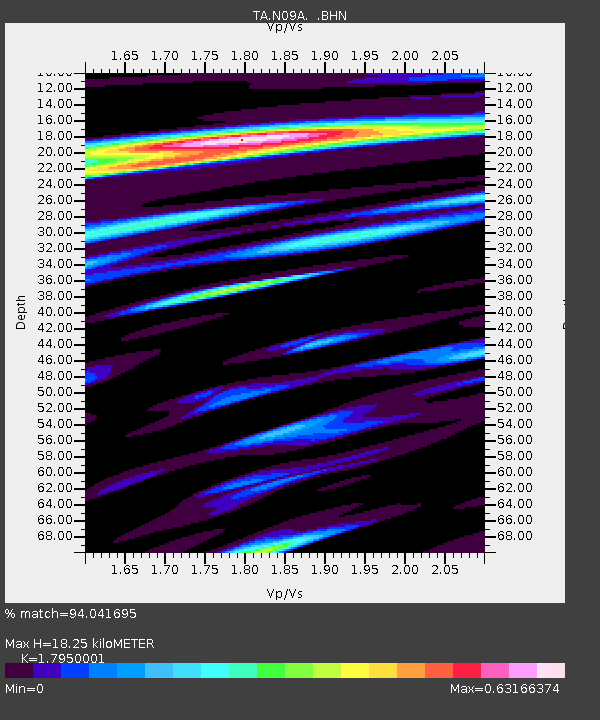
| Estimated Moho Depth: |
18.25 km |
| Estimated Crust Vp/Vs: |
1.80 |
| Assumed Crust Vp: |
6.276 km/s |
| Estimated Crust Vs: |
3.496 km/s |
| Estimated Crust Poisson's Ratio: |
0.27 |
|
| Radial Match: |
94.041695 % |
| Radial Bump: |
400 |
| Transverse Match: |
80.58163 % |
| Transverse Bump: |
400 |
| SOD ConfigId: |
2665 |
| Insert Time: |
2010-03-07 01:23:10.760 +0000 |
| GWidth: |
2.5 |
| Max Bumps: |
400 |
| Tol: |
0.001 |
|
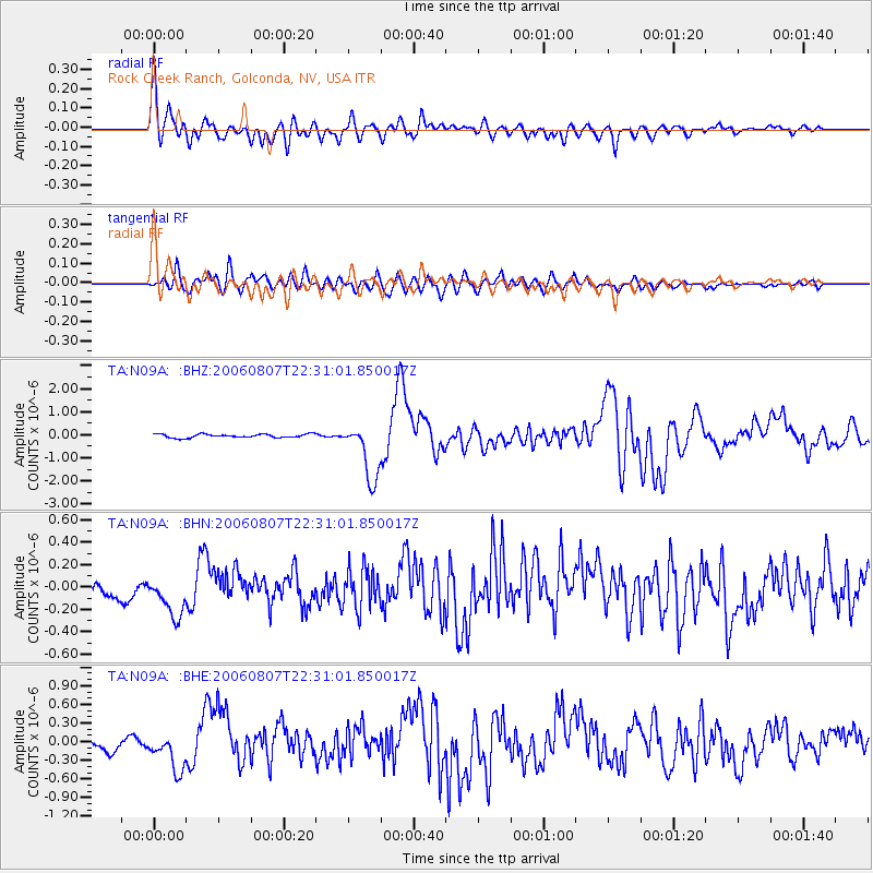
Signal To Noise
| Channel | StoN | STA | LTA |
| TA:N09A: :BHN:20060807T22:31:01.850017Z | 2.6109543 | 2.0634123E-7 | 7.902905E-8 |
| TA:N09A: :BHE:20060807T22:31:01.850017Z | 4.4996142 | 2.9404063E-7 | 6.534796E-8 |
| TA:N09A: :BHZ:20060807T22:31:01.850017Z | 16.317535 | 1.2598448E-6 | 7.720803E-8 |
| Arrivals |
| Ps | 2.4 SECOND |
| PpPs | 8.0 SECOND |
| PsPs/PpSs | 10 SECOND |


