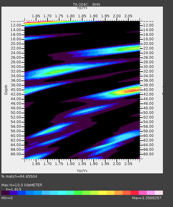
Q04C Lincoln, CA, USA - Earthquake Result Viewer
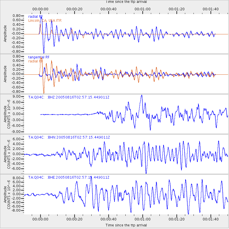
Earthquake location: Near East Coast Of Honshu, Japan
Earthquake latitude/longitude: 38.3/142.0
Earthquake time(UTC): 2005/08/16 (228) 02:46:28 GMT
Earthquake Depth: 36 km
Earthquake Magnitude: 6.5 MB, 6.8 MS, 7.2 MW, 7.1 MW
Earthquake Catalog/Contributor: WHDF/NEIC
Network: TA USArray Transportable Network (new EarthScope stations)
Station: Q04C Lincoln, CA, USA
Lat/Lon: 38.84 N/121.38 W
Elevation: 14 m
Distance: 71.7 deg
Az: 54.823 deg
Baz: 304.538 deg
Ray Param: 0.054129243
Estimated Moho Depth: 10.0 km
Estimated Crust Vp/Vs: 1.62
Assumed Crust Vp: 6.597 km/s
Estimated Crust Vs: 4.085 km/s
Estimated Crust Poisson's Ratio: 0.19
Radial Match: 94.65504 %
Radial Bump: 400
Transverse Match: 90.38762 %
Transverse Bump: 400
SOD ConfigId: 2475
Insert Time: 2010-03-07 01:23:58.131 +0000
GWidth: 2.5
Max Bumps: 400
Tol: 0.001

Signal To Noise

ChannelStoNSTALTA
TA:Q04C: :BHN:20050816T02:57:15.449011Z1.18500092.778228E-72.3444944E-7
TA:Q04C: :BHE:20050816T02:57:15.449011Z1.3580253.7960675E-72.7952854E-7
TA:Q04C: :BHZ:20050816T02:57:15.449011Z7.0942036.065949E-78.550571E-8
Arrivals
Ps1.0 SECOND
PpPs3.8 SECOND
PsPs/PpSs4.8 SECOND