You are here: Home > Network List > TA - USArray Transportable Network (new EarthScope stations) Stations List
> Station H22K Ishtalitna Creek, AK, USA > Earthquake Result Viewer
H22K Ishtalitna Creek, AK, USA - Earthquake Result Viewer
| Earthquake location: |
Western Iran |
| Earthquake latitude/longitude: |
31.8/49.5 |
| Earthquake time(UTC): |
2019/07/08 (189) 07:00:31 GMT |
| Earthquake Depth: |
10 km |
| Earthquake Magnitude: |
5.7 mb |
| Earthquake Catalog/Contributor: |
NEIC PDE/us |
|
| Network: |
TA USArray Transportable Network (new EarthScope stations) |
| Station: |
H22K Ishtalitna Creek, AK, USA |
| Lat/Lon: |
65.89 N/151.38 W |
| Elevation: |
561 m |
|
| Distance: |
81.3 deg |
| Az: |
8.531 deg |
| Baz: |
342.083 deg |
| Ray Param: |
0.04767441 |
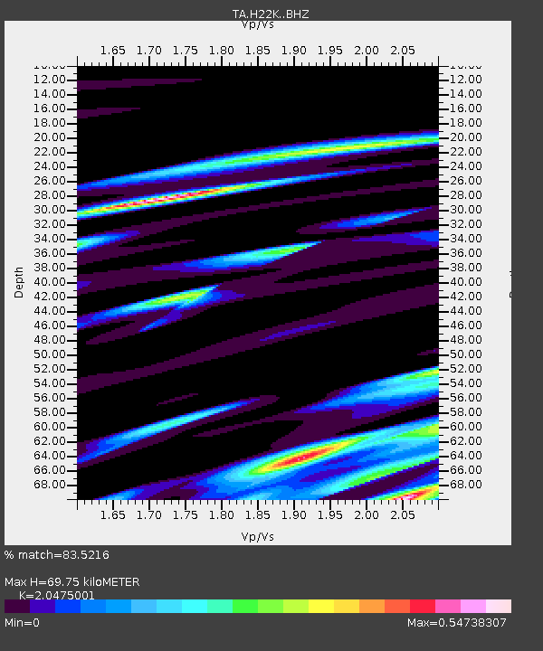
| Estimated Moho Depth: |
69.75 km |
| Estimated Crust Vp/Vs: |
2.05 |
| Assumed Crust Vp: |
6.566 km/s |
| Estimated Crust Vs: |
3.207 km/s |
| Estimated Crust Poisson's Ratio: |
0.34 |
|
| Radial Match: |
83.5216 % |
| Radial Bump: |
400 |
| Transverse Match: |
80.7547 % |
| Transverse Bump: |
400 |
| SOD ConfigId: |
19053131 |
| Insert Time: |
2019-07-22 07:06:23.047 +0000 |
| GWidth: |
2.5 |
| Max Bumps: |
400 |
| Tol: |
0.001 |
|

Signal To Noise
| Channel | StoN | STA | LTA |
| TA:H22K: :BHZ:20190708T07:12:16.450024Z | 4.751269 | 4.297281E-7 | 9.044491E-8 |
| TA:H22K: :BHN:20190708T07:12:16.450024Z | 1.8583187 | 1.4565144E-7 | 7.837807E-8 |
| TA:H22K: :BHE:20190708T07:12:16.450024Z | 1.3210876 | 7.021891E-8 | 5.3152352E-8 |
| Arrivals |
| Ps | 11 SECOND |
| PpPs | 32 SECOND |
| PsPs/PpSs | 43 SECOND |


