You are here: Home > Network List > TA - USArray Transportable Network (new EarthScope stations) Stations List
> Station Q04C Lincoln, CA, USA > Earthquake Result Viewer
Q04C Lincoln, CA, USA - Earthquake Result Viewer

| Earthquake location: |
Panama-Costa Rica Border Region |
| Earthquake latitude/longitude: |
8.4/-82.9 |
| Earthquake time(UTC): |
2005/06/30 (181) 21:26:36 GMT |
| Earthquake Depth: |
38 km |
| Earthquake Magnitude: |
5.3 MB, 5.6 MS, 6.0 MW, 5.8 MW |
| Earthquake Catalog/Contributor: |
WHDF/NEIC |
|
| Network: |
TA USArray Transportable Network (new EarthScope stations) |
| Station: |
Q04C Lincoln, CA, USA |
| Lat/Lon: |
38.84 N/121.38 W |
| Elevation: |
14 m |
|
| Distance: |
45.9 deg |
| Az: |
317.398 deg |
| Baz: |
120.966 deg |
| Ray Param: |
0.07089066 |
| Estimated Moho Depth: |
11.75 km |
| Estimated Crust Vp/Vs: |
1.60 |
| Assumed Crust Vp: |
6.597 km/s |
| Estimated Crust Vs: |
4.123 km/s |
| Estimated Crust Poisson's Ratio: |
0.18 |
|
| Radial Match: |
85.08656 % |
| Radial Bump: |
400 |
| Transverse Match: |
77.60189 % |
| Transverse Bump: |
400 |
| SOD ConfigId: |
142937 |
| Insert Time: |
2010-03-07 01:24:11.581 +0000 |
| GWidth: |
2.5 |
| Max Bumps: |
400 |
| Tol: |
0.001 |
|
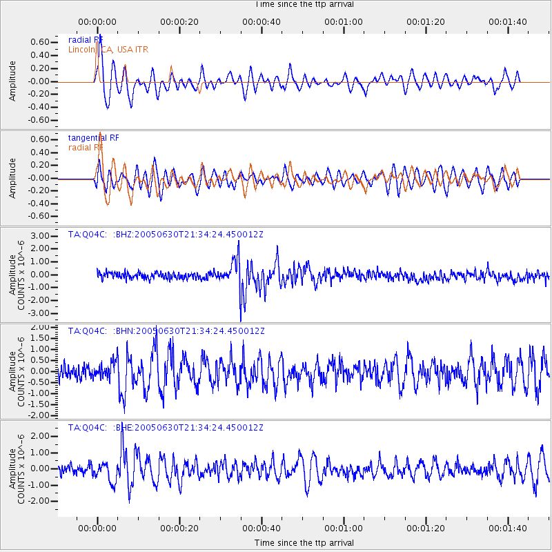
Signal To Noise
| Channel | StoN | STA | LTA |
| TA:Q04C: :BHN:20050630T21:34:24.450012Z | 1.2070777 | 3.5940855E-7 | 2.9775094E-7 |
| TA:Q04C: :BHE:20050630T21:34:24.450012Z | 1.9045316 | 5.844285E-7 | 3.0686206E-7 |
| TA:Q04C: :BHZ:20050630T21:34:24.450012Z | 4.499381 | 1.0162817E-6 | 2.2587143E-7 |
| Arrivals |
| Ps | 1.2 SECOND |
| PpPs | 4.3 SECOND |
| PsPs/PpSs | 5.5 SECOND |


