You are here: Home > Network List > TA - USArray Transportable Network (new EarthScope stations) Stations List
> Station M27K Edge Creek, AK, USA > Earthquake Result Viewer
M27K Edge Creek, AK, USA - Earthquake Result Viewer
| Earthquake location: |
Western Iran |
| Earthquake latitude/longitude: |
31.8/49.5 |
| Earthquake time(UTC): |
2019/07/08 (189) 07:00:31 GMT |
| Earthquake Depth: |
10 km |
| Earthquake Magnitude: |
5.7 mb |
| Earthquake Catalog/Contributor: |
NEIC PDE/us |
|
| Network: |
TA USArray Transportable Network (new EarthScope stations) |
| Station: |
M27K Edge Creek, AK, USA |
| Lat/Lon: |
62.36 N/141.88 W |
| Elevation: |
1536 m |
|
| Distance: |
85.7 deg |
| Az: |
5.313 deg |
| Baz: |
350.264 deg |
| Ray Param: |
0.044543404 |
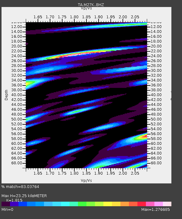
| Estimated Moho Depth: |
23.25 km |
| Estimated Crust Vp/Vs: |
1.82 |
| Assumed Crust Vp: |
6.566 km/s |
| Estimated Crust Vs: |
3.618 km/s |
| Estimated Crust Poisson's Ratio: |
0.28 |
|
| Radial Match: |
83.03764 % |
| Radial Bump: |
400 |
| Transverse Match: |
72.12637 % |
| Transverse Bump: |
400 |
| SOD ConfigId: |
19053131 |
| Insert Time: |
2019-07-22 07:06:50.122 +0000 |
| GWidth: |
2.5 |
| Max Bumps: |
400 |
| Tol: |
0.001 |
|

Signal To Noise
| Channel | StoN | STA | LTA |
| TA:M27K: :BHZ:20190708T07:12:39.125012Z | 2.1744714 | 3.41648E-7 | 1.5711773E-7 |
| TA:M27K: :BHN:20190708T07:12:39.125012Z | 2.7038236 | 2.1249753E-7 | 7.859149E-8 |
| TA:M27K: :BHE:20190708T07:12:39.125012Z | 0.8933821 | 1.1627927E-7 | 1.3015625E-7 |
| Arrivals |
| Ps | 3.0 SECOND |
| PpPs | 9.7 SECOND |
| PsPs/PpSs | 13 SECOND |


