You are here: Home > Network List > TA - USArray Transportable Network (new EarthScope stations) Stations List
> Station Q04C Lincoln, CA, USA > Earthquake Result Viewer
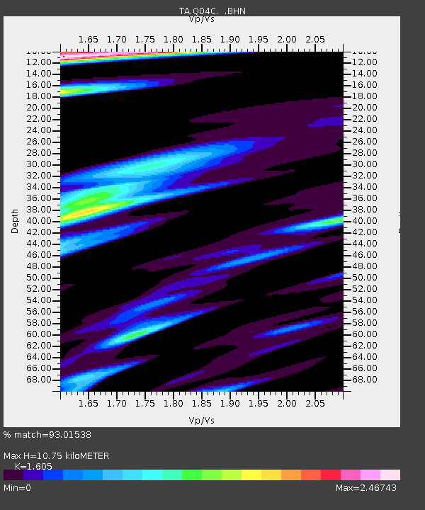
Q04C Lincoln, CA, USA - Earthquake Result Viewer
| Earthquake location: |
South Of Kermadec Islands |
| Earthquake latitude/longitude: |
-32.6/-179.4 |
| Earthquake time(UTC): |
2005/05/16 (136) 03:54:14 GMT |
| Earthquake Depth: |
34 km |
| Earthquake Magnitude: |
6.2 MB, 6.4 MS, 6.6 MW, 6.6 MW |
| Earthquake Catalog/Contributor: |
WHDF/NEIC |
|
| Network: |
TA USArray Transportable Network (new EarthScope stations) |
| Station: |
Q04C Lincoln, CA, USA |
| Lat/Lon: |
38.84 N/121.38 W |
| Elevation: |
14 m |
|
| Distance: |
89.2 deg |
| Az: |
41.467 deg |
| Baz: |
225.709 deg |
| Ray Param: |
0.0420158 |
| Estimated Moho Depth: |
10.75 km |
| Estimated Crust Vp/Vs: |
1.61 |
| Assumed Crust Vp: |
6.597 km/s |
| Estimated Crust Vs: |
4.111 km/s |
| Estimated Crust Poisson's Ratio: |
0.18 |
|
| Radial Match: |
93.01538 % |
| Radial Bump: |
336 |
| Transverse Match: |
84.99813 % |
| Transverse Bump: |
400 |
| SOD ConfigId: |
142939 |
| Insert Time: |
2010-03-07 01:24:14.250 +0000 |
| GWidth: |
2.5 |
| Max Bumps: |
400 |
| Tol: |
0.001 |
|

Signal To Noise
| Channel | StoN | STA | LTA |
| TA:Q04C: :BHN:20050516T04:06:35.424016Z | 3.3369377 | 6.576297E-7 | 1.970758E-7 |
| TA:Q04C: :BHE:20050516T04:06:35.424016Z | 4.1600623 | 7.296777E-7 | 1.7540067E-7 |
| TA:Q04C: :BHZ:20050516T04:06:35.424016Z | 9.82655 | 1.06679E-6 | 1.08562006E-7 |
| Arrivals |
| Ps | 1.0 SECOND |
| PpPs | 4.1 SECOND |
| PsPs/PpSs | 5.2 SECOND |


