You are here: Home > Network List > TA - USArray Transportable Network (new EarthScope stations) Stations List
> Station P16K Nushagak River, AK, USA > Earthquake Result Viewer
P16K Nushagak River, AK, USA - Earthquake Result Viewer
| Earthquake location: |
Western Iran |
| Earthquake latitude/longitude: |
31.8/49.5 |
| Earthquake time(UTC): |
2019/07/08 (189) 07:00:31 GMT |
| Earthquake Depth: |
10 km |
| Earthquake Magnitude: |
5.7 mb |
| Earthquake Catalog/Contributor: |
NEIC PDE/us |
|
| Network: |
TA USArray Transportable Network (new EarthScope stations) |
| Station: |
P16K Nushagak River, AK, USA |
| Lat/Lon: |
59.03 N/157.99 W |
| Elevation: |
86 m |
|
| Distance: |
86.7 deg |
| Az: |
13.854 deg |
| Baz: |
336.773 deg |
| Ray Param: |
0.043878656 |
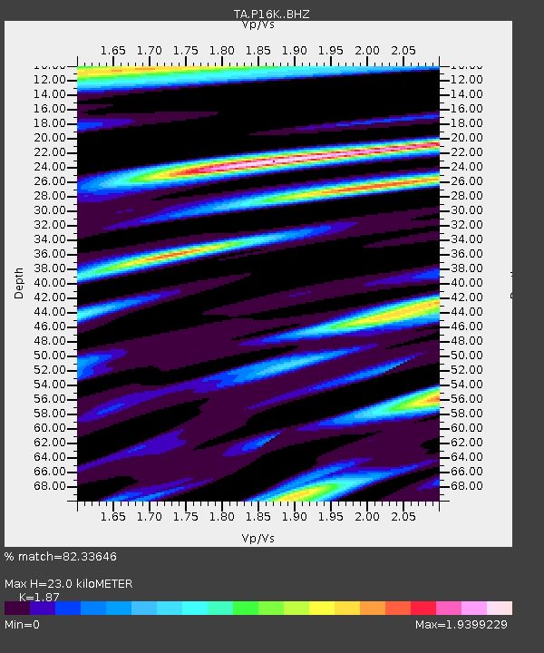
| Estimated Moho Depth: |
23.0 km |
| Estimated Crust Vp/Vs: |
1.87 |
| Assumed Crust Vp: |
6.276 km/s |
| Estimated Crust Vs: |
3.356 km/s |
| Estimated Crust Poisson's Ratio: |
0.30 |
|
| Radial Match: |
82.33646 % |
| Radial Bump: |
400 |
| Transverse Match: |
84.89768 % |
| Transverse Bump: |
400 |
| SOD ConfigId: |
19053131 |
| Insert Time: |
2019-07-22 07:07:01.182 +0000 |
| GWidth: |
2.5 |
| Max Bumps: |
400 |
| Tol: |
0.001 |
|

Signal To Noise
| Channel | StoN | STA | LTA |
| TA:P16K: :BHZ:20190708T07:12:43.700024Z | 3.670198 | 4.5711778E-7 | 1.2454855E-7 |
| TA:P16K: :BHN:20190708T07:12:43.700024Z | 1.14157 | 2.1102184E-7 | 1.8485231E-7 |
| TA:P16K: :BHE:20190708T07:12:43.700024Z | 1.6220692 | 2.8331635E-7 | 1.7466354E-7 |
| Arrivals |
| Ps | 3.3 SECOND |
| PpPs | 10 SECOND |
| PsPs/PpSs | 14 SECOND |


