You are here: Home > Network List > TA - USArray Transportable Network (new EarthScope stations) Stations List
> Station Q04C Lincoln, CA, USA > Earthquake Result Viewer
Q04C Lincoln, CA, USA - Earthquake Result Viewer
| Earthquake location: |
Kuril Islands |
| Earthquake latitude/longitude: |
45.8/150.1 |
| Earthquake time(UTC): |
2007/09/03 (246) 16:14:53 GMT |
| Earthquake Depth: |
94 km |
| Earthquake Magnitude: |
6.3 MB, 6.2 MW, 6.2 ME |
| Earthquake Catalog/Contributor: |
WHDF/NEIC |
|
| Network: |
TA USArray Transportable Network (new EarthScope stations) |
| Station: |
Q04C Lincoln, CA, USA |
| Lat/Lon: |
38.84 N/121.38 W |
| Elevation: |
14 m |
|
| Distance: |
62.6 deg |
| Az: |
61.571 deg |
| Baz: |
308.071 deg |
| Ray Param: |
0.059870273 |
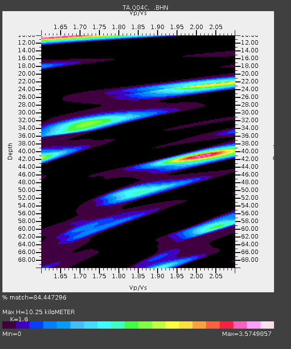
| Estimated Moho Depth: |
10.25 km |
| Estimated Crust Vp/Vs: |
1.60 |
| Assumed Crust Vp: |
6.597 km/s |
| Estimated Crust Vs: |
4.123 km/s |
| Estimated Crust Poisson's Ratio: |
0.18 |
|
| Radial Match: |
84.447296 % |
| Radial Bump: |
400 |
| Transverse Match: |
66.820724 % |
| Transverse Bump: |
400 |
| SOD ConfigId: |
2564 |
| Insert Time: |
2010-03-07 01:24:19.783 +0000 |
| GWidth: |
2.5 |
| Max Bumps: |
400 |
| Tol: |
0.001 |
|

Signal To Noise
| Channel | StoN | STA | LTA |
| TA:Q04C: :BHN:20070903T16:24:37.075005Z | 5.108641 | 1.6057747E-6 | 3.143252E-7 |
| TA:Q04C: :BHE:20070903T16:24:37.075005Z | 12.593739 | 2.7992803E-6 | 2.2227556E-7 |
| TA:Q04C: :BHZ:20070903T16:24:37.075005Z | 14.496098 | 2.531411E-6 | 1.7462706E-7 |
| Arrivals |
| Ps | 1.0 SECOND |
| PpPs | 3.8 SECOND |
| PsPs/PpSs | 4.8 SECOND |


