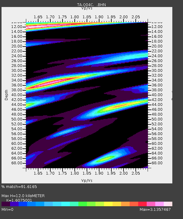
Q04C Lincoln, CA, USA - Earthquake Result Viewer
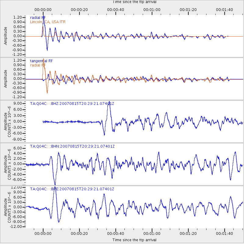
Earthquake location: Andreanof Islands, Aleutian Is.
Earthquake latitude/longitude: 50.3/-177.5
Earthquake time(UTC): 2007/08/15 (227) 20:22:11 GMT
Earthquake Depth: 9.0 km
Earthquake Magnitude: 6.3 MB, 6.2 MS, 6.4 MW, 5.9 ML
Earthquake Catalog/Contributor: WHDF/NEIC
Network: TA USArray Transportable Network (new EarthScope stations)
Station: Q04C Lincoln, CA, USA
Lat/Lon: 38.84 N/121.38 W
Elevation: 14 m
Distance: 40.7 deg
Az: 84.134 deg
Baz: 305.264 deg
Ray Param: 0.07424722
Estimated Moho Depth: 12.0 km
Estimated Crust Vp/Vs: 1.61
Assumed Crust Vp: 6.597 km/s
Estimated Crust Vs: 4.104 km/s
Estimated Crust Poisson's Ratio: 0.18
Radial Match: 91.6165 %
Radial Bump: 400
Transverse Match: 77.14511 %
Transverse Bump: 400
SOD ConfigId: 2564
Insert Time: 2010-03-07 01:24:24.051 +0000
GWidth: 2.5
Max Bumps: 400
Tol: 0.001

Signal To Noise

ChannelStoNSTALTA
TA:Q04C: :BHN:20070815T20:29:21.07401Z4.18463661.2119565E-62.896205E-7
TA:Q04C: :BHE:20070815T20:29:21.07401Z5.985082.6117202E-64.3637183E-7
TA:Q04C: :BHZ:20070815T20:29:21.07401Z10.58182052.349073E-62.2199136E-7
Arrivals
Ps1.2 SECOND
PpPs4.4 SECOND
PsPs/PpSs5.6 SECOND