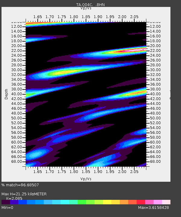
Q04C Lincoln, CA, USA - Earthquake Result Viewer
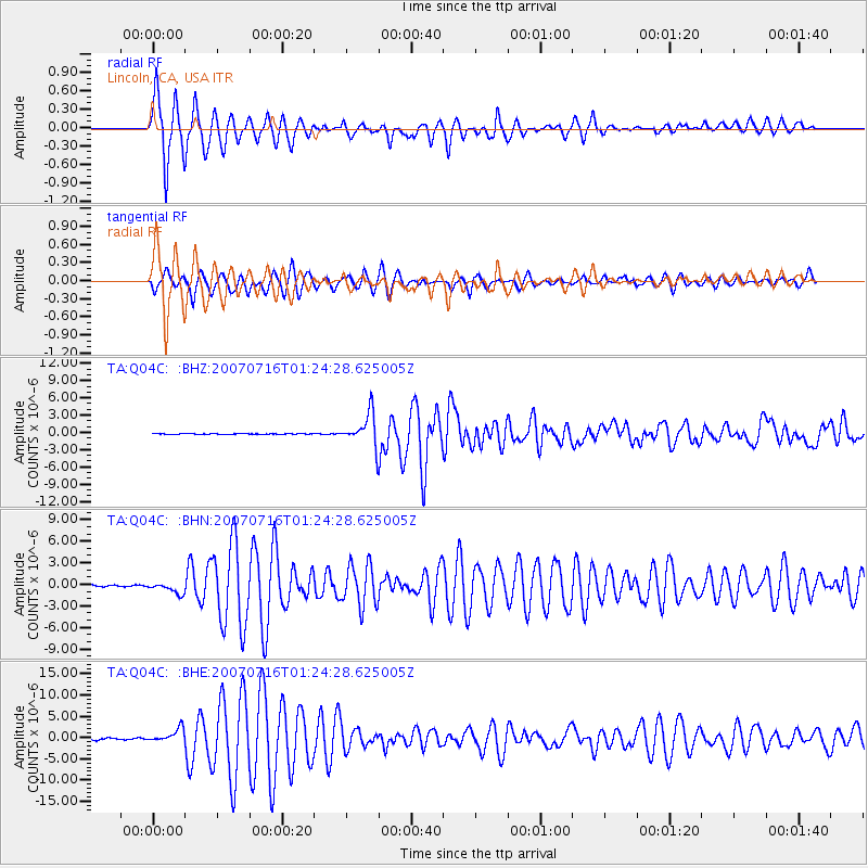
Earthquake location: Near West Coast Of Honshu, Japan
Earthquake latitude/longitude: 37.5/138.4
Earthquake time(UTC): 2007/07/16 (197) 01:13:22 GMT
Earthquake Depth: 12 km
Earthquake Magnitude: 6.5 MB, 6.4 MS, 6.6 MW, 6.5 MW
Earthquake Catalog/Contributor: WHDF/NEIC
Network: TA USArray Transportable Network (new EarthScope stations)
Station: Q04C Lincoln, CA, USA
Lat/Lon: 38.84 N/121.38 W
Elevation: 14 m
Distance: 74.4 deg
Az: 52.953 deg
Baz: 305.665 deg
Ray Param: 0.052367155
Estimated Moho Depth: 21.25 km
Estimated Crust Vp/Vs: 2.09
Assumed Crust Vp: 6.597 km/s
Estimated Crust Vs: 3.164 km/s
Estimated Crust Poisson's Ratio: 0.35
Radial Match: 96.68507 %
Radial Bump: 377
Transverse Match: 84.10916 %
Transverse Bump: 400
SOD ConfigId: 2564
Insert Time: 2010-03-07 01:24:29.872 +0000
GWidth: 2.5
Max Bumps: 400
Tol: 0.001

Signal To Noise

ChannelStoNSTALTA
TA:Q04C: :BHN:20070716T01:24:28.625005Z5.0572417.383613E-71.460008E-7
TA:Q04C: :BHE:20070716T01:24:28.625005Z6.41219571.5730369E-62.4531954E-7
TA:Q04C: :BHZ:20070716T01:24:28.625005Z37.387142.8317681E-67.5741774E-8
Arrivals
Ps3.6 SECOND
PpPs9.6 SECOND
PsPs/PpSs13 SECOND