You are here: Home > Network List > TA - USArray Transportable Network (new EarthScope stations) Stations List
> Station Q04C Lincoln, CA, USA > Earthquake Result Viewer
Q04C Lincoln, CA, USA - Earthquake Result Viewer
| Earthquake location: |
East Of Kuril Islands |
| Earthquake latitude/longitude: |
46.2/154.5 |
| Earthquake time(UTC): |
2007/01/13 (013) 04:23:21 GMT |
| Earthquake Depth: |
10 km |
| Earthquake Magnitude: |
7.3 MB, 8.2 MS, 8.1 MW, 7.9 MW |
| Earthquake Catalog/Contributor: |
WHDF/NEIC |
|
| Network: |
TA USArray Transportable Network (new EarthScope stations) |
| Station: |
Q04C Lincoln, CA, USA |
| Lat/Lon: |
38.84 N/121.38 W |
| Elevation: |
14 m |
|
| Distance: |
59.6 deg |
| Az: |
64.192 deg |
| Baz: |
306.866 deg |
| Ray Param: |
0.062053233 |
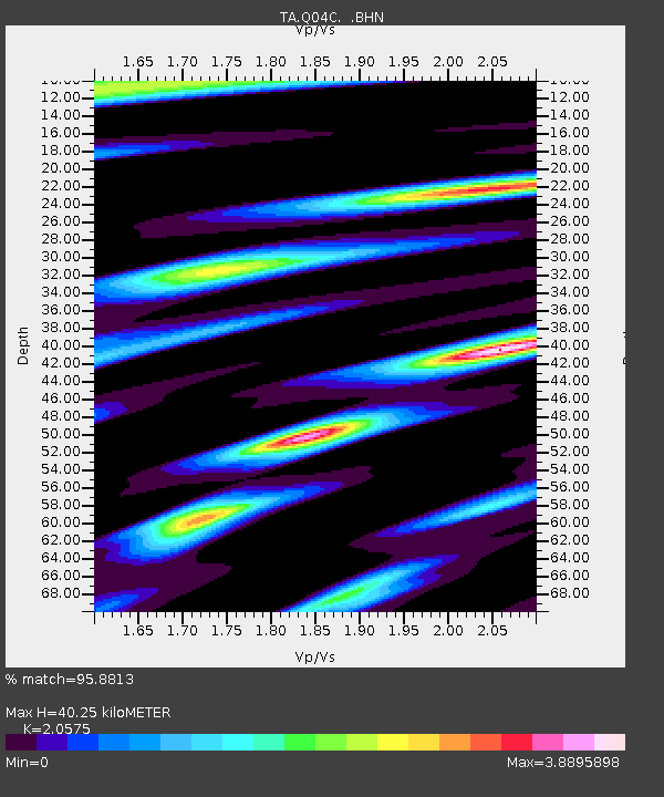
| Estimated Moho Depth: |
40.25 km |
| Estimated Crust Vp/Vs: |
2.06 |
| Assumed Crust Vp: |
6.597 km/s |
| Estimated Crust Vs: |
3.207 km/s |
| Estimated Crust Poisson's Ratio: |
0.35 |
|
| Radial Match: |
95.8813 % |
| Radial Bump: |
400 |
| Transverse Match: |
89.22412 % |
| Transverse Bump: |
400 |
| SOD ConfigId: |
2564 |
| Insert Time: |
2010-03-07 01:24:41.433 +0000 |
| GWidth: |
2.5 |
| Max Bumps: |
400 |
| Tol: |
0.001 |
|
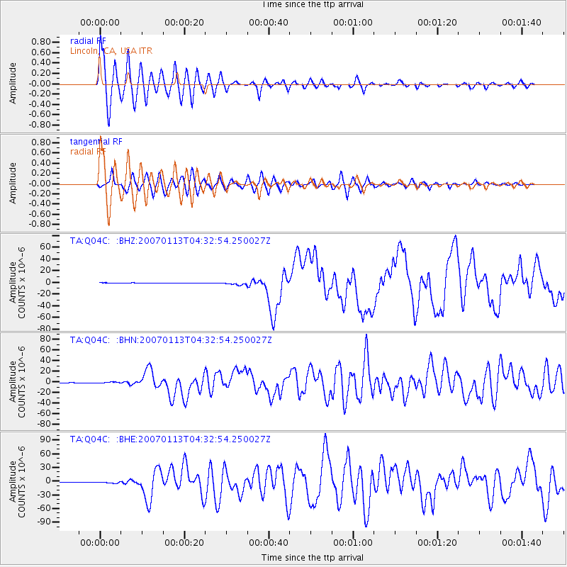
Signal To Noise
| Channel | StoN | STA | LTA |
| TA:Q04C: :BHN:20070113T04:32:54.250027Z | 2.5344298 | 9.846984E-7 | 3.8852858E-7 |
| TA:Q04C: :BHE:20070113T04:32:54.250027Z | 5.2874823 | 1.636719E-6 | 3.09546E-7 |
| TA:Q04C: :BHZ:20070113T04:32:54.250027Z | 7.4645724 | 2.3643631E-6 | 3.167446E-7 |
| Arrivals |
| Ps | 6.7 SECOND |
| PpPs | 18 SECOND |
| PsPs/PpSs | 25 SECOND |


