You are here: Home > Network List > TA - USArray Transportable Network (new EarthScope stations) Stations List
> Station Q04C Lincoln, CA, USA > Earthquake Result Viewer
Q04C Lincoln, CA, USA - Earthquake Result Viewer
| Earthquake location: |
Near Coast Of Nicaragua |
| Earthquake latitude/longitude: |
11.1/-87.8 |
| Earthquake time(UTC): |
2006/11/18 (322) 10:05:44 GMT |
| Earthquake Depth: |
30 km |
| Earthquake Magnitude: |
5.1 MB, 4.7 MS, 5.5 MW, 5.5 MW |
| Earthquake Catalog/Contributor: |
WHDF/NEIC |
|
| Network: |
TA USArray Transportable Network (new EarthScope stations) |
| Station: |
Q04C Lincoln, CA, USA |
| Lat/Lon: |
38.84 N/121.38 W |
| Elevation: |
14 m |
|
| Distance: |
40.7 deg |
| Az: |
318.521 deg |
| Baz: |
123.652 deg |
| Ray Param: |
0.07419852 |
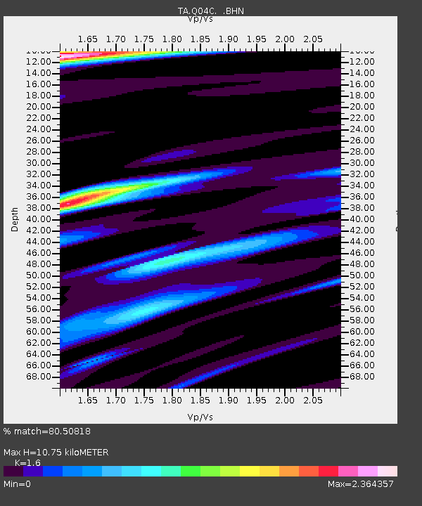
| Estimated Moho Depth: |
10.75 km |
| Estimated Crust Vp/Vs: |
1.60 |
| Assumed Crust Vp: |
6.597 km/s |
| Estimated Crust Vs: |
4.123 km/s |
| Estimated Crust Poisson's Ratio: |
0.18 |
|
| Radial Match: |
80.50818 % |
| Radial Bump: |
400 |
| Transverse Match: |
86.25104 % |
| Transverse Bump: |
341 |
| SOD ConfigId: |
2564 |
| Insert Time: |
2010-03-07 01:24:47.536 +0000 |
| GWidth: |
2.5 |
| Max Bumps: |
400 |
| Tol: |
0.001 |
|

Signal To Noise
| Channel | StoN | STA | LTA |
| TA:Q04C: :BHN:20061118T10:12:51.425Z | 2.7543905 | 9.441589E-7 | 3.4278327E-7 |
| TA:Q04C: :BHE:20061118T10:12:51.425Z | 1.6100734 | 1.0168621E-6 | 6.3156256E-7 |
| TA:Q04C: :BHZ:20061118T10:12:51.425Z | 2.300985 | 9.111942E-7 | 3.9600178E-7 |
| Arrivals |
| Ps | 1.1 SECOND |
| PpPs | 3.9 SECOND |
| PsPs/PpSs | 5.0 SECOND |


