You are here: Home > Network List > TA - USArray Transportable Network (new EarthScope stations) Stations List
> Station Q04C Lincoln, CA, USA > Earthquake Result Viewer
Q04C Lincoln, CA, USA - Earthquake Result Viewer
| Earthquake location: |
Off Coast Of Mexico |
| Earthquake latitude/longitude: |
8.4/-103.2 |
| Earthquake time(UTC): |
2006/10/11 (284) 06:00:48 GMT |
| Earthquake Depth: |
10 km |
| Earthquake Magnitude: |
5.2 MB, 5.4 MS, 5.8 MW, 5.7 MW |
| Earthquake Catalog/Contributor: |
WHDF/NEIC |
|
| Network: |
TA USArray Transportable Network (new EarthScope stations) |
| Station: |
Q04C Lincoln, CA, USA |
| Lat/Lon: |
38.84 N/121.38 W |
| Elevation: |
14 m |
|
| Distance: |
34.4 deg |
| Az: |
334.435 deg |
| Baz: |
146.859 deg |
| Ray Param: |
0.077738345 |
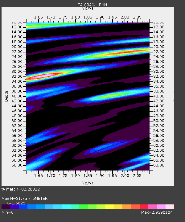
| Estimated Moho Depth: |
31.75 km |
| Estimated Crust Vp/Vs: |
1.66 |
| Assumed Crust Vp: |
6.597 km/s |
| Estimated Crust Vs: |
3.968 km/s |
| Estimated Crust Poisson's Ratio: |
0.22 |
|
| Radial Match: |
82.20322 % |
| Radial Bump: |
358 |
| Transverse Match: |
73.67869 % |
| Transverse Bump: |
400 |
| SOD ConfigId: |
2665 |
| Insert Time: |
2010-03-07 01:24:54.932 +0000 |
| GWidth: |
2.5 |
| Max Bumps: |
400 |
| Tol: |
0.001 |
|

Signal To Noise
| Channel | StoN | STA | LTA |
| TA:Q04C: :BHN:20061011T06:07:05.223015Z | 1.574966 | 3.076832E-7 | 1.9535864E-7 |
| TA:Q04C: :BHE:20061011T06:07:05.223015Z | 1.4001753 | 3.8649844E-7 | 2.7603573E-7 |
| TA:Q04C: :BHZ:20061011T06:07:05.223015Z | 2.3823898 | 2.8920698E-7 | 1.2139365E-7 |
| Arrivals |
| Ps | 3.5 SECOND |
| PpPs | 12 SECOND |
| PsPs/PpSs | 15 SECOND |


