You are here: Home > Network List > AV - Alaska Volcano Observatory Stations List
> Station MAPS Pakushin Southeast, Makushin Volcano, Alaska > Earthquake Result Viewer
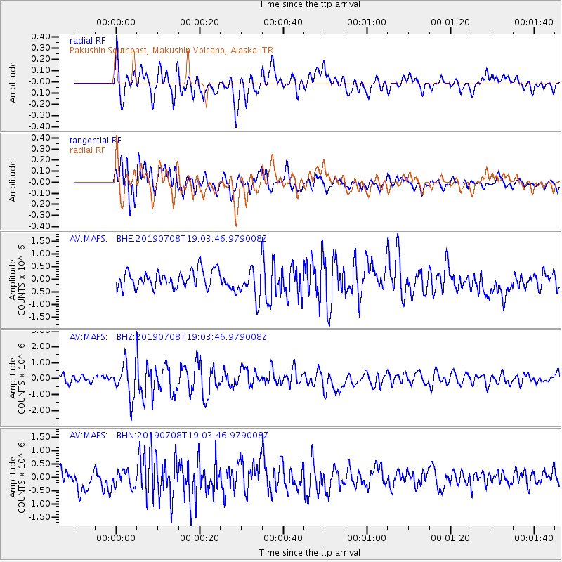
MAPS Pakushin Southeast, Makushin Volcano, Alaska - Earthquake Result Viewer
*The percent match for this event was below the threshold and hence no stack was calculated.
| Earthquake location: |
Northern Molucca Sea |
| Earthquake latitude/longitude: |
0.5/126.3 |
| Earthquake time(UTC): |
2019/07/08 (189) 18:52:33 GMT |
| Earthquake Depth: |
28 km |
| Earthquake Magnitude: |
5.9 Mww |
| Earthquake Catalog/Contributor: |
NEIC PDE/us |
|
| Network: |
AV Alaska Volcano Observatory |
| Station: |
MAPS Pakushin Southeast, Makushin Volcano, Alaska |
| Lat/Lon: |
53.81 N/166.94 W |
| Elevation: |
333 m |
|
| Distance: |
76.1 deg |
| Az: |
34.158 deg |
| Baz: |
251.206 deg |
| Ray Param: |
$rayparam |
*The percent match for this event was below the threshold and hence was not used in the summary stack. |
|
| Radial Match: |
71.46452 % |
| Radial Bump: |
400 |
| Transverse Match: |
68.22443 % |
| Transverse Bump: |
400 |
| SOD ConfigId: |
19053131 |
| Insert Time: |
2019-07-22 18:54:23.392 +0000 |
| GWidth: |
2.5 |
| Max Bumps: |
400 |
| Tol: |
0.001 |
|
Signal To Noise
| Channel | StoN | STA | LTA |
| AV:MAPS: :BHZ:20190708T19:03:46.979008Z | 4.240902 | 1.2092437E-6 | 2.8513836E-7 |
| AV:MAPS: :BHN:20190708T19:03:46.979008Z | 0.7992112 | 2.92679E-7 | 3.6620983E-7 |
| AV:MAPS: :BHE:20190708T19:03:46.979008Z | 1.9627619 | 6.5550745E-7 | 3.3397197E-7 |
| Arrivals |
| Ps | |
| PpPs | |
| PsPs/PpSs | |


