You are here: Home > Network List > TA - USArray Transportable Network (new EarthScope stations) Stations List
> Station Q04C Lincoln, CA, USA > Earthquake Result Viewer
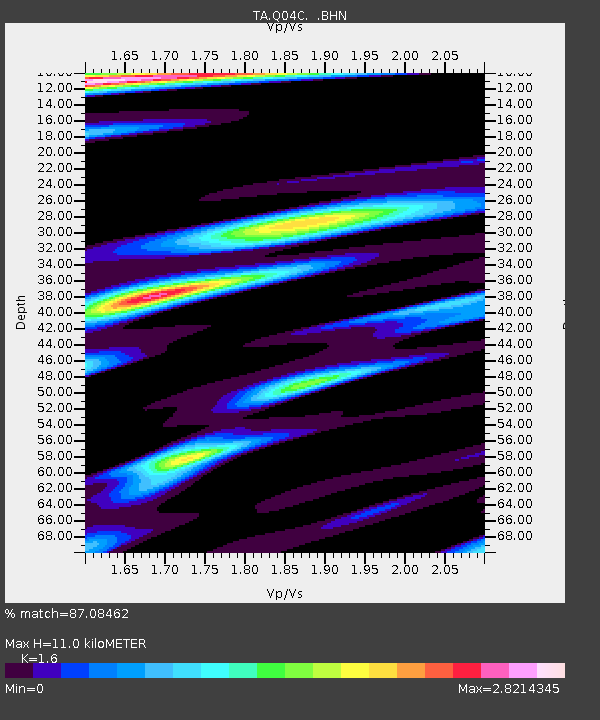
Q04C Lincoln, CA, USA - Earthquake Result Viewer
| Earthquake location: |
Samoa Islands Region |
| Earthquake latitude/longitude: |
-16.6/-172.0 |
| Earthquake time(UTC): |
2006/09/28 (271) 06:22:09 GMT |
| Earthquake Depth: |
28 km |
| Earthquake Magnitude: |
6.5 MB, 6.6 MS, 6.9 MW, 6.7 MW |
| Earthquake Catalog/Contributor: |
WHDF/NEIC |
|
| Network: |
TA USArray Transportable Network (new EarthScope stations) |
| Station: |
Q04C Lincoln, CA, USA |
| Lat/Lon: |
38.84 N/121.38 W |
| Elevation: |
14 m |
|
| Distance: |
72.7 deg |
| Az: |
39.243 deg |
| Baz: |
230.962 deg |
| Ray Param: |
0.053456333 |
| Estimated Moho Depth: |
11.0 km |
| Estimated Crust Vp/Vs: |
1.60 |
| Assumed Crust Vp: |
6.597 km/s |
| Estimated Crust Vs: |
4.123 km/s |
| Estimated Crust Poisson's Ratio: |
0.18 |
|
| Radial Match: |
87.08462 % |
| Radial Bump: |
327 |
| Transverse Match: |
77.72828 % |
| Transverse Bump: |
400 |
| SOD ConfigId: |
2665 |
| Insert Time: |
2010-03-07 01:25:02.322 +0000 |
| GWidth: |
2.5 |
| Max Bumps: |
400 |
| Tol: |
0.001 |
|

Signal To Noise
| Channel | StoN | STA | LTA |
| TA:Q04C: :BHN:20060928T06:33:03.87502Z | 16.375433 | 2.1651879E-6 | 1.3222173E-7 |
| TA:Q04C: :BHE:20060928T06:33:03.87502Z | 29.068407 | 3.5179853E-6 | 1.2102436E-7 |
| TA:Q04C: :BHZ:20060928T06:33:03.87502Z | 30.188353 | 3.4594743E-6 | 1.14596325E-7 |
| Arrivals |
| Ps | 1.0 SECOND |
| PpPs | 4.2 SECOND |
| PsPs/PpSs | 5.2 SECOND |


