You are here: Home > Network List > TA - USArray Transportable Network (new EarthScope stations) Stations List
> Station Q04C Lincoln, CA, USA > Earthquake Result Viewer
Q04C Lincoln, CA, USA - Earthquake Result Viewer
| Earthquake location: |
Near East Coast Of Kamchatka |
| Earthquake latitude/longitude: |
51.1/157.5 |
| Earthquake time(UTC): |
2006/08/24 (236) 21:50:36 GMT |
| Earthquake Depth: |
43 km |
| Earthquake Magnitude: |
5.9 MB, 6.2 MS, 6.5 MW, 6.5 MW |
| Earthquake Catalog/Contributor: |
WHDF/NEIC |
|
| Network: |
TA USArray Transportable Network (new EarthScope stations) |
| Station: |
Q04C Lincoln, CA, USA |
| Lat/Lon: |
38.84 N/121.38 W |
| Elevation: |
14 m |
|
| Distance: |
55.9 deg |
| Az: |
68.781 deg |
| Baz: |
311.25 deg |
| Ray Param: |
0.06442448 |
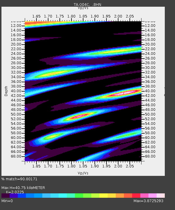
| Estimated Moho Depth: |
40.75 km |
| Estimated Crust Vp/Vs: |
2.02 |
| Assumed Crust Vp: |
6.597 km/s |
| Estimated Crust Vs: |
3.262 km/s |
| Estimated Crust Poisson's Ratio: |
0.34 |
|
| Radial Match: |
90.80171 % |
| Radial Bump: |
400 |
| Transverse Match: |
84.67938 % |
| Transverse Bump: |
400 |
| SOD ConfigId: |
2665 |
| Insert Time: |
2010-03-07 01:25:10.411 +0000 |
| GWidth: |
2.5 |
| Max Bumps: |
400 |
| Tol: |
0.001 |
|
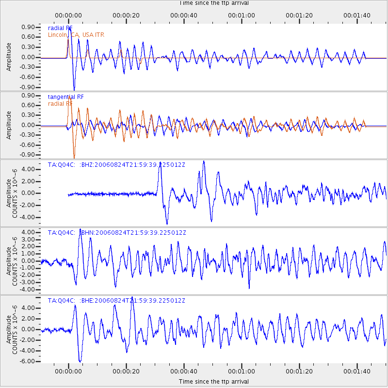
Signal To Noise
| Channel | StoN | STA | LTA |
| TA:Q04C: :BHN:20060824T21:59:39.225012Z | 10.142387 | 2.083338E-6 | 2.0540902E-7 |
| TA:Q04C: :BHE:20060824T21:59:39.225012Z | 7.773535 | 3.1090335E-6 | 3.9995106E-7 |
| TA:Q04C: :BHZ:20060824T21:59:39.225012Z | 24.368343 | 2.8444608E-6 | 1.1672771E-7 |
| Arrivals |
| Ps | 6.6 SECOND |
| PpPs | 18 SECOND |
| PsPs/PpSs | 24 SECOND |


