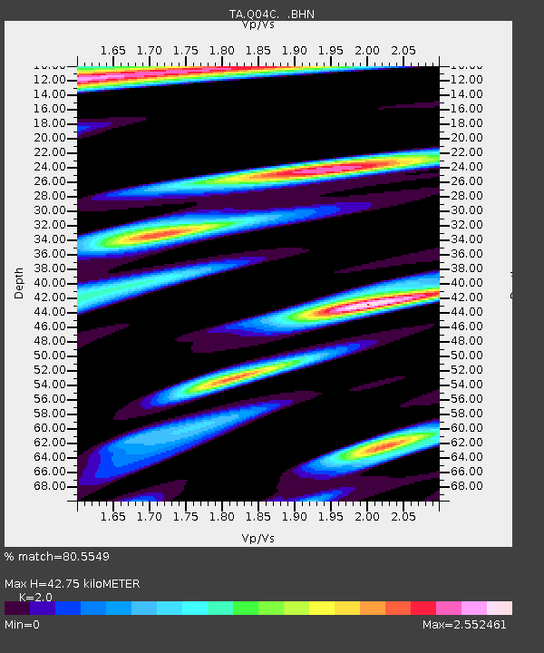
Q04C Lincoln, CA, USA - Earthquake Result Viewer
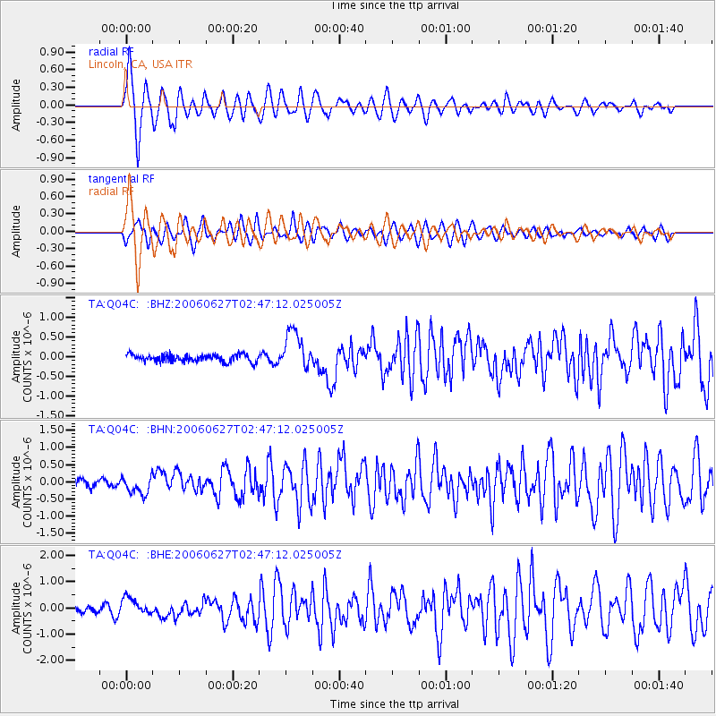
Earthquake location: Rat Islands, Aleutian Islands
Earthquake latitude/longitude: 52.2/176.2
Earthquake time(UTC): 2006/06/27 (178) 02:39:35 GMT
Earthquake Depth: 34 km
Earthquake Magnitude: 5.6 MB, 6.0 MS, 6.2 MW, 6.2 MW
Earthquake Catalog/Contributor: WHDF/NEIC
Network: TA USArray Transportable Network (new EarthScope stations)
Station: Q04C Lincoln, CA, USA
Lat/Lon: 38.84 N/121.38 W
Elevation: 14 m
Distance: 44.4 deg
Az: 81.817 deg
Baz: 308.741 deg
Ray Param: 0.07188394
Estimated Moho Depth: 42.75 km
Estimated Crust Vp/Vs: 2.00
Assumed Crust Vp: 6.597 km/s
Estimated Crust Vs: 3.299 km/s
Estimated Crust Poisson's Ratio: 0.33
Radial Match: 80.5549 %
Radial Bump: 400
Transverse Match: 78.655 %
Transverse Bump: 400
SOD ConfigId: 2665
Insert Time: 2010-03-07 01:25:21.111 +0000
GWidth: 2.5
Max Bumps: 400
Tol: 0.001

Signal To Noise

ChannelStoNSTALTA
TA:Q04C: :BHN:20060627T02:47:12.025005Z1.86806292.5762333E-71.3790934E-7
TA:Q04C: :BHE:20060627T02:47:12.025005Z1.16184743.270797E-72.8151692E-7
TA:Q04C: :BHZ:20060627T02:47:12.025005Z5.3364644.9238884E-79.2268735E-8
Arrivals
Ps6.9 SECOND
PpPs18 SECOND
PsPs/PpSs25 SECOND