You are here: Home > Network List > II - Global Seismograph Network (GSN - IRIS/IDA) Stations List
> Station WRAB Tennant Creek, NT, Australia > Earthquake Result Viewer
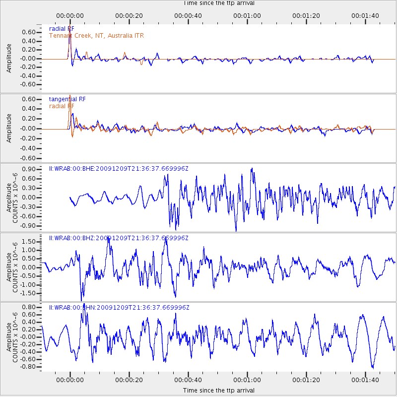
WRAB Tennant Creek, NT, Australia - Earthquake Result Viewer
*The percent match for this event was below the threshold and hence no stack was calculated.
| Earthquake location: |
Off W Coast Of Northern Sumatra |
| Earthquake latitude/longitude: |
2.8/95.9 |
| Earthquake time(UTC): |
2009/12/09 (343) 21:29:02 GMT |
| Earthquake Depth: |
19 km |
| Earthquake Magnitude: |
5.7 MB, 5.9 MS, 6.0 MW, 6.0 MW |
| Earthquake Catalog/Contributor: |
WHDF/NEIC |
|
| Network: |
II Global Seismograph Network (GSN - IRIS/IDA) |
| Station: |
WRAB Tennant Creek, NT, Australia |
| Lat/Lon: |
19.93 S/134.36 E |
| Elevation: |
366 m |
|
| Distance: |
44.0 deg |
| Az: |
122.581 deg |
| Baz: |
296.542 deg |
| Ray Param: |
$rayparam |
*The percent match for this event was below the threshold and hence was not used in the summary stack. |
|
| Radial Match: |
66.29411 % |
| Radial Bump: |
400 |
| Transverse Match: |
67.12052 % |
| Transverse Bump: |
400 |
| SOD ConfigId: |
1 |
| Insert Time: |
2010-02-19 01:21:08.046 +0000 |
| GWidth: |
2.5 |
| Max Bumps: |
400 |
| Tol: |
0.001 |
|
Signal To Noise
| Channel | StoN | STA | LTA |
| II:WRAB:00:BHZ:20091209T21:36:37.669996Z | 2.8486805 | 8.0528525E-7 | 2.826871E-7 |
| II:WRAB:00:BHN:20091209T21:36:37.669996Z | 1.3589131 | 4.3609344E-7 | 3.2091344E-7 |
| II:WRAB:00:BHE:20091209T21:36:37.669996Z | 3.2497811 | 4.167265E-7 | 1.2823217E-7 |
| Arrivals |
| Ps | |
| PpPs | |
| PsPs/PpSs | |


