You are here: Home > Network List > TA - USArray Transportable Network (new EarthScope stations) Stations List
> Station Q04C Lincoln, CA, USA > Earthquake Result Viewer
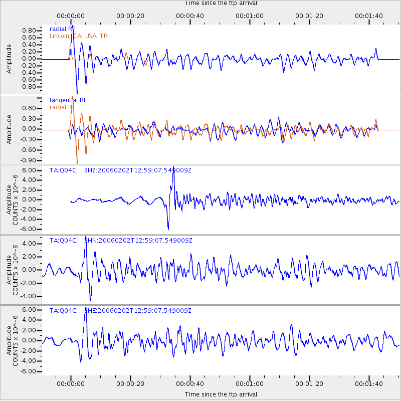
Q04C Lincoln, CA, USA - Earthquake Result Viewer

| Earthquake location: |
Fiji Islands Region |
| Earthquake latitude/longitude: |
-17.7/-178.4 |
| Earthquake time(UTC): |
2006/02/02 (033) 12:48:43 GMT |
| Earthquake Depth: |
598 km |
| Earthquake Magnitude: |
5.9 MB, 6.7 MW, 6.7 MW |
| Earthquake Catalog/Contributor: |
WHDF/NEIC |
|
| Network: |
TA USArray Transportable Network (new EarthScope stations) |
| Station: |
Q04C Lincoln, CA, USA |
| Lat/Lon: |
38.84 N/121.38 W |
| Elevation: |
14 m |
|
| Distance: |
77.5 deg |
| Az: |
42.137 deg |
| Baz: |
234.955 deg |
| Ray Param: |
0.04836438 |
| Estimated Moho Depth: |
11.0 km |
| Estimated Crust Vp/Vs: |
1.60 |
| Assumed Crust Vp: |
6.597 km/s |
| Estimated Crust Vs: |
4.117 km/s |
| Estimated Crust Poisson's Ratio: |
0.18 |
|
| Radial Match: |
82.015305 % |
| Radial Bump: |
400 |
| Transverse Match: |
57.83424 % |
| Transverse Bump: |
400 |
| SOD ConfigId: |
4977 |
| Insert Time: |
2010-03-07 01:25:43.836 +0000 |
| GWidth: |
2.5 |
| Max Bumps: |
400 |
| Tol: |
0.001 |
|
Signal To Noise
| Channel | StoN | STA | LTA |
| TA:Q04C: :BHN:20060202T12:59:07.549009Z | 2.5935657 | 1.1875342E-6 | 4.5787704E-7 |
| TA:Q04C: :BHE:20060202T12:59:07.549009Z | 4.9589233 | 2.038424E-6 | 4.1106185E-7 |
| TA:Q04C: :BHZ:20060202T12:59:07.549009Z | 8.5083275 | 2.7718647E-6 | 3.2578257E-7 |
| Arrivals |
| Ps | 1.0 SECOND |
| PpPs | 4.2 SECOND |
| PsPs/PpSs | 5.2 SECOND |


