You are here: Home > Network List > TA - USArray Transportable Network (new EarthScope stations) Stations List
> Station Q04C Lincoln, CA, USA > Earthquake Result Viewer
Q04C Lincoln, CA, USA - Earthquake Result Viewer
| Earthquake location: |
Near West Coast Of Colombia |
| Earthquake latitude/longitude: |
6.9/-77.8 |
| Earthquake time(UTC): |
2006/01/23 (023) 20:50:44 GMT |
| Earthquake Depth: |
14 km |
| Earthquake Magnitude: |
6.1 MB, 5.9 MS, 6.2 MW, 6.1 MW |
| Earthquake Catalog/Contributor: |
WHDF/NEIC |
|
| Network: |
TA USArray Transportable Network (new EarthScope stations) |
| Station: |
Q04C Lincoln, CA, USA |
| Lat/Lon: |
38.84 N/121.38 W |
| Elevation: |
14 m |
|
| Distance: |
50.5 deg |
| Az: |
315.766 deg |
| Baz: |
117.51 deg |
| Ray Param: |
0.067994 |
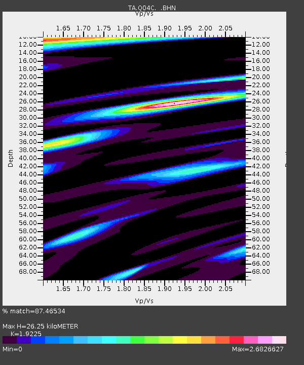
| Estimated Moho Depth: |
26.25 km |
| Estimated Crust Vp/Vs: |
1.92 |
| Assumed Crust Vp: |
6.597 km/s |
| Estimated Crust Vs: |
3.432 km/s |
| Estimated Crust Poisson's Ratio: |
0.31 |
|
| Radial Match: |
87.46534 % |
| Radial Bump: |
330 |
| Transverse Match: |
82.55545 % |
| Transverse Bump: |
400 |
| SOD ConfigId: |
4977 |
| Insert Time: |
2010-03-07 01:25:47.237 +0000 |
| GWidth: |
2.5 |
| Max Bumps: |
400 |
| Tol: |
0.001 |
|
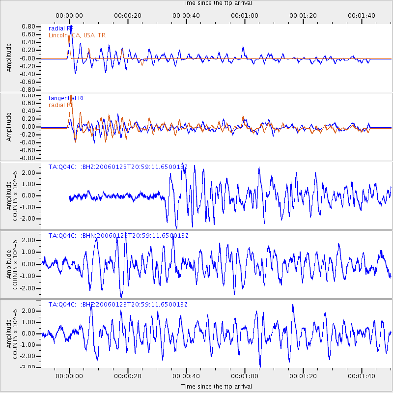
Signal To Noise
| Channel | StoN | STA | LTA |
| TA:Q04C: :BHN:20060123T20:59:11.650013Z | 1.7586693 | 4.1338282E-7 | 2.3505433E-7 |
| TA:Q04C: :BHE:20060123T20:59:11.650013Z | 1.3984785 | 4.1663958E-7 | 2.9792346E-7 |
| TA:Q04C: :BHZ:20060123T20:59:11.650013Z | 5.1255426 | 9.182103E-7 | 1.7914401E-7 |
| Arrivals |
| Ps | 3.9 SECOND |
| PpPs | 11 SECOND |
| PsPs/PpSs | 15 SECOND |


