You are here: Home > Network List > TA - USArray Transportable Network (new EarthScope stations) Stations List
> Station C16K Lisburne Hills, AK, USA > Earthquake Result Viewer
C16K Lisburne Hills, AK, USA - Earthquake Result Viewer
| Earthquake location: |
Northern Molucca Sea |
| Earthquake latitude/longitude: |
0.5/126.3 |
| Earthquake time(UTC): |
2019/07/08 (189) 18:52:33 GMT |
| Earthquake Depth: |
28 km |
| Earthquake Magnitude: |
5.9 Mww |
| Earthquake Catalog/Contributor: |
NEIC PDE/us |
|
| Network: |
TA USArray Transportable Network (new EarthScope stations) |
| Station: |
C16K Lisburne Hills, AK, USA |
| Lat/Lon: |
68.27 N/165.34 W |
| Elevation: |
102 m |
|
| Distance: |
81.7 deg |
| Az: |
20.473 deg |
| Baz: |
249.953 deg |
| Ray Param: |
0.04740096 |
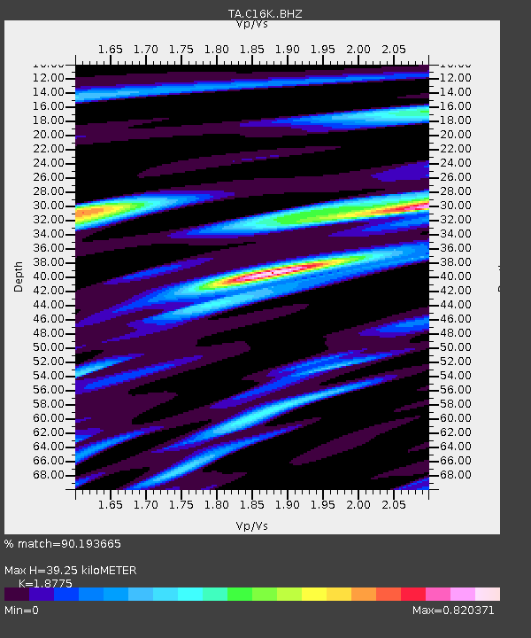
| Estimated Moho Depth: |
39.25 km |
| Estimated Crust Vp/Vs: |
1.88 |
| Assumed Crust Vp: |
5.906 km/s |
| Estimated Crust Vs: |
3.146 km/s |
| Estimated Crust Poisson's Ratio: |
0.30 |
|
| Radial Match: |
90.193665 % |
| Radial Bump: |
400 |
| Transverse Match: |
83.68526 % |
| Transverse Bump: |
400 |
| SOD ConfigId: |
19053131 |
| Insert Time: |
2019-07-22 18:56:27.439 +0000 |
| GWidth: |
2.5 |
| Max Bumps: |
400 |
| Tol: |
0.001 |
|
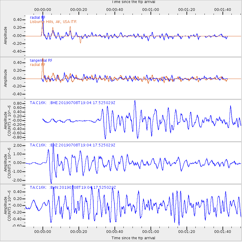
Signal To Noise
| Channel | StoN | STA | LTA |
| TA:C16K: :BHZ:20190708T19:04:17.525029Z | 13.797073 | 9.548195E-7 | 6.9204496E-8 |
| TA:C16K: :BHN:20190708T19:04:17.525029Z | 3.044859 | 1.7966228E-7 | 5.9005124E-8 |
| TA:C16K: :BHE:20190708T19:04:17.525029Z | 7.753219 | 3.166545E-7 | 4.084168E-8 |
| Arrivals |
| Ps | 6.0 SECOND |
| PpPs | 19 SECOND |
| PsPs/PpSs | 25 SECOND |


