You are here: Home > Network List > TA - USArray Transportable Network (new EarthScope stations) Stations List
> Station E18K Tukpahlearik Creek, AK, USA > Earthquake Result Viewer
E18K Tukpahlearik Creek, AK, USA - Earthquake Result Viewer
| Earthquake location: |
Northern Molucca Sea |
| Earthquake latitude/longitude: |
0.5/126.3 |
| Earthquake time(UTC): |
2019/07/08 (189) 18:52:33 GMT |
| Earthquake Depth: |
28 km |
| Earthquake Magnitude: |
5.9 Mww |
| Earthquake Catalog/Contributor: |
NEIC PDE/us |
|
| Network: |
TA USArray Transportable Network (new EarthScope stations) |
| Station: |
E18K Tukpahlearik Creek, AK, USA |
| Lat/Lon: |
67.42 N/160.60 W |
| Elevation: |
297 m |
|
| Distance: |
83.1 deg |
| Az: |
21.849 deg |
| Baz: |
254.523 deg |
| Ray Param: |
0.046391368 |
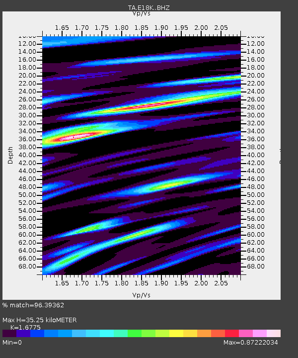
| Estimated Moho Depth: |
35.25 km |
| Estimated Crust Vp/Vs: |
1.68 |
| Assumed Crust Vp: |
6.276 km/s |
| Estimated Crust Vs: |
3.741 km/s |
| Estimated Crust Poisson's Ratio: |
0.22 |
|
| Radial Match: |
96.39362 % |
| Radial Bump: |
400 |
| Transverse Match: |
93.03629 % |
| Transverse Bump: |
400 |
| SOD ConfigId: |
19053131 |
| Insert Time: |
2019-07-22 18:56:37.346 +0000 |
| GWidth: |
2.5 |
| Max Bumps: |
400 |
| Tol: |
0.001 |
|

Signal To Noise
| Channel | StoN | STA | LTA |
| TA:E18K: :BHZ:20190708T19:04:25.075017Z | 13.404265 | 7.7931594E-7 | 5.81394E-8 |
| TA:E18K: :BHN:20190708T19:04:25.075017Z | 5.6870136 | 1.4836026E-7 | 2.6087552E-8 |
| TA:E18K: :BHE:20190708T19:04:25.075017Z | 9.387923 | 2.5984238E-7 | 2.7678366E-8 |
| Arrivals |
| Ps | 3.9 SECOND |
| PpPs | 15 SECOND |
| PsPs/PpSs | 19 SECOND |


