You are here: Home > Network List > TA - USArray Transportable Network (new EarthScope stations) Stations List
> Station Q04C Lincoln, CA, USA > Earthquake Result Viewer
Q04C Lincoln, CA, USA - Earthquake Result Viewer
| Earthquake location: |
El Salvador |
| Earthquake latitude/longitude: |
13.4/-89.4 |
| Earthquake time(UTC): |
2004/12/13 (348) 15:23:41 GMT |
| Earthquake Depth: |
62 km |
| Earthquake Magnitude: |
5.4 MB, 6.0 MW, 5.9 MW |
| Earthquake Catalog/Contributor: |
WHDF/NEIC |
|
| Network: |
TA USArray Transportable Network (new EarthScope stations) |
| Station: |
Q04C Lincoln, CA, USA |
| Lat/Lon: |
38.84 N/121.38 W |
| Elevation: |
14 m |
|
| Distance: |
38.0 deg |
| Az: |
317.737 deg |
| Baz: |
123.064 deg |
| Ray Param: |
0.07564178 |
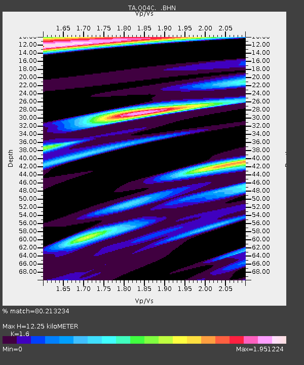
| Estimated Moho Depth: |
12.25 km |
| Estimated Crust Vp/Vs: |
1.60 |
| Assumed Crust Vp: |
6.597 km/s |
| Estimated Crust Vs: |
4.123 km/s |
| Estimated Crust Poisson's Ratio: |
0.18 |
|
| Radial Match: |
80.213234 % |
| Radial Bump: |
400 |
| Transverse Match: |
51.159126 % |
| Transverse Bump: |
400 |
| SOD ConfigId: |
2459 |
| Insert Time: |
2010-03-07 01:25:54.137 +0000 |
| GWidth: |
2.5 |
| Max Bumps: |
400 |
| Tol: |
0.001 |
|
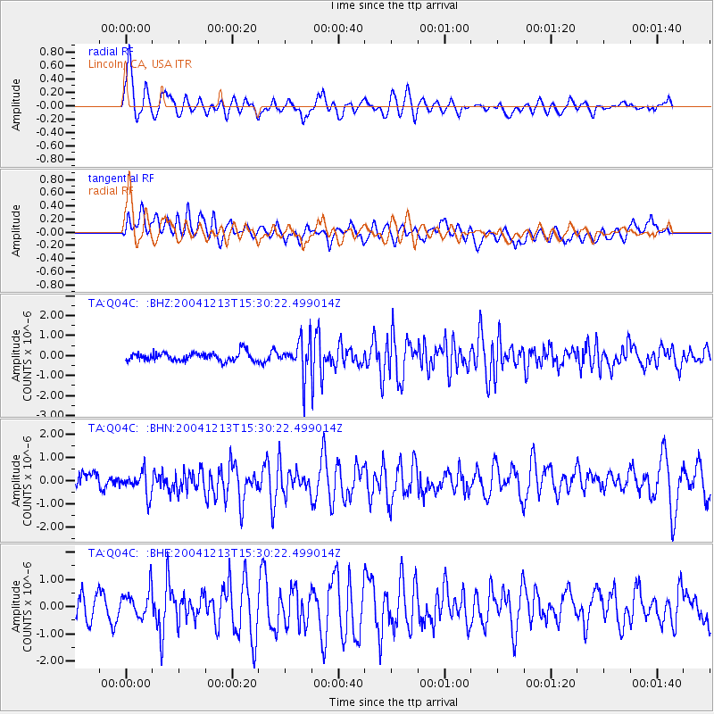
Signal To Noise
| Channel | StoN | STA | LTA |
| TA:Q04C: :BHN:20041213T15:30:22.499014Z | 1.2063756 | 5.491454E-7 | 4.5520264E-7 |
| TA:Q04C: :BHE:20041213T15:30:22.499014Z | 1.2672622 | 5.183319E-7 | 4.0901708E-7 |
| TA:Q04C: :BHZ:20041213T15:30:22.499014Z | 4.2379622 | 9.1810136E-7 | 2.1663745E-7 |
| Arrivals |
| Ps | 1.2 SECOND |
| PpPs | 4.4 SECOND |
| PsPs/PpSs | 5.6 SECOND |


