You are here: Home > Network List > TA - USArray Transportable Network (new EarthScope stations) Stations List
> Station F26K Sheenjek River, AK, USA > Earthquake Result Viewer
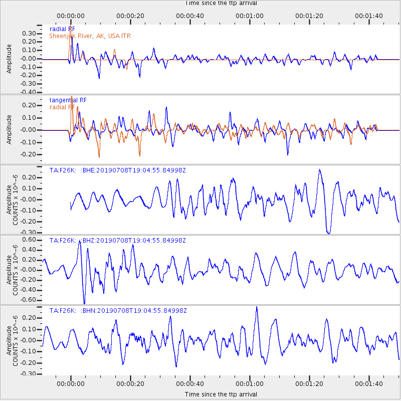
F26K Sheenjek River, AK, USA - Earthquake Result Viewer
*The percent match for this event was below the threshold and hence no stack was calculated.
| Earthquake location: |
Northern Molucca Sea |
| Earthquake latitude/longitude: |
0.5/126.3 |
| Earthquake time(UTC): |
2019/07/08 (189) 18:52:33 GMT |
| Earthquake Depth: |
28 km |
| Earthquake Magnitude: |
5.9 Mww |
| Earthquake Catalog/Contributor: |
NEIC PDE/us |
|
| Network: |
TA USArray Transportable Network (new EarthScope stations) |
| Station: |
F26K Sheenjek River, AK, USA |
| Lat/Lon: |
67.69 N/144.15 W |
| Elevation: |
683 m |
|
| Distance: |
89.4 deg |
| Az: |
22.442 deg |
| Baz: |
269.773 deg |
| Ray Param: |
$rayparam |
*The percent match for this event was below the threshold and hence was not used in the summary stack. |
|
| Radial Match: |
60.15195 % |
| Radial Bump: |
400 |
| Transverse Match: |
53.557697 % |
| Transverse Bump: |
326 |
| SOD ConfigId: |
19053131 |
| Insert Time: |
2019-07-22 18:56:47.476 +0000 |
| GWidth: |
2.5 |
| Max Bumps: |
400 |
| Tol: |
0.001 |
|
Signal To Noise
| Channel | StoN | STA | LTA |
| TA:F26K: :BHZ:20190708T19:04:55.84998Z | 2.47547 | 3.309926E-7 | 1.33709E-7 |
| TA:F26K: :BHN:20190708T19:04:55.84998Z | 0.7066641 | 7.728094E-8 | 1.09360215E-7 |
| TA:F26K: :BHE:20190708T19:04:55.84998Z | 1.9251454 | 9.278454E-8 | 4.819612E-8 |
| Arrivals |
| Ps | |
| PpPs | |
| PsPs/PpSs | |


