You are here: Home > Network List > TA - USArray Transportable Network (new EarthScope stations) Stations List
> Station Q04C Lincoln, CA, USA > Earthquake Result Viewer
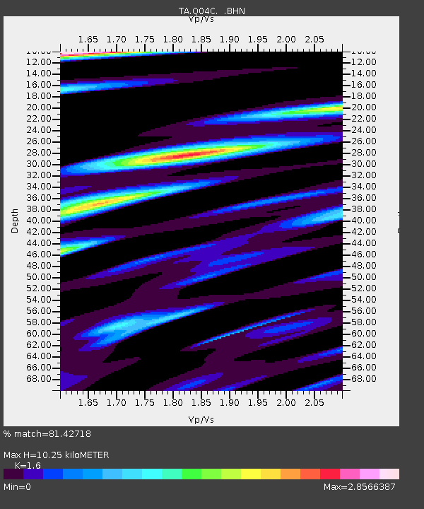
Q04C Lincoln, CA, USA - Earthquake Result Viewer
| Earthquake location: |
Kermadec Islands Region |
| Earthquake latitude/longitude: |
-27.0/-176.3 |
| Earthquake time(UTC): |
2005/07/11 (192) 23:06:01 GMT |
| Earthquake Depth: |
10 km |
| Earthquake Magnitude: |
5.5 MB, 5.7 MS, 6.0 MW, 5.9 MW |
| Earthquake Catalog/Contributor: |
WHDF/NEIC |
|
| Network: |
TA USArray Transportable Network (new EarthScope stations) |
| Station: |
Q04C Lincoln, CA, USA |
| Lat/Lon: |
38.84 N/121.38 W |
| Elevation: |
14 m |
|
| Distance: |
83.2 deg |
| Az: |
40.076 deg |
| Baz: |
227.352 deg |
| Ray Param: |
0.046348024 |
| Estimated Moho Depth: |
10.25 km |
| Estimated Crust Vp/Vs: |
1.60 |
| Assumed Crust Vp: |
6.597 km/s |
| Estimated Crust Vs: |
4.123 km/s |
| Estimated Crust Poisson's Ratio: |
0.18 |
|
| Radial Match: |
81.42718 % |
| Radial Bump: |
400 |
| Transverse Match: |
49.310738 % |
| Transverse Bump: |
400 |
| SOD ConfigId: |
132717 |
| Insert Time: |
2010-03-07 01:25:58.447 +0000 |
| GWidth: |
2.5 |
| Max Bumps: |
400 |
| Tol: |
0.001 |
|

Signal To Noise
| Channel | StoN | STA | LTA |
| TA:Q04C: :BHN:20050711T23:17:56.674021Z | 1.4070207 | 5.6165516E-7 | 3.991805E-7 |
| TA:Q04C: :BHE:20050711T23:17:56.674021Z | 1.5252192 | 4.0278854E-7 | 2.6408566E-7 |
| TA:Q04C: :BHZ:20050711T23:17:56.674021Z | 2.0300655 | 3.785185E-7 | 1.8645629E-7 |
| Arrivals |
| Ps | 1.0 SECOND |
| PpPs | 3.9 SECOND |
| PsPs/PpSs | 4.9 SECOND |


