You are here: Home > Network List > TA - USArray Transportable Network (new EarthScope stations) Stations List
> Station G21K Allakaket, AK, USA > Earthquake Result Viewer
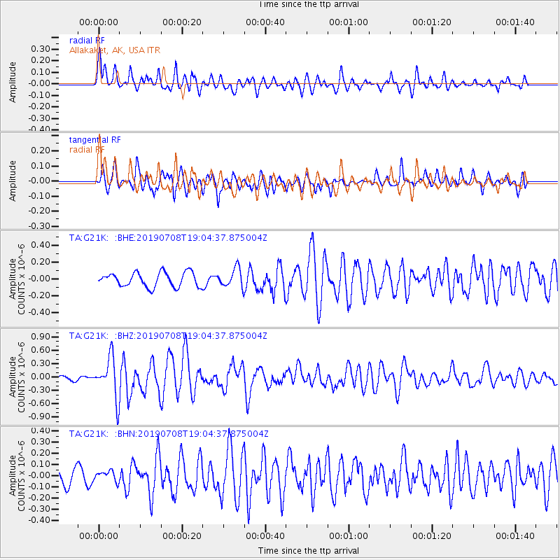
G21K Allakaket, AK, USA - Earthquake Result Viewer
*The percent match for this event was below the threshold and hence no stack was calculated.
| Earthquake location: |
Northern Molucca Sea |
| Earthquake latitude/longitude: |
0.5/126.3 |
| Earthquake time(UTC): |
2019/07/08 (189) 18:52:33 GMT |
| Earthquake Depth: |
28 km |
| Earthquake Magnitude: |
5.9 Mww |
| Earthquake Catalog/Contributor: |
NEIC PDE/us |
|
| Network: |
TA USArray Transportable Network (new EarthScope stations) |
| Station: |
G21K Allakaket, AK, USA |
| Lat/Lon: |
66.52 N/153.51 W |
| Elevation: |
446 m |
|
| Distance: |
85.6 deg |
| Az: |
23.331 deg |
| Baz: |
261.194 deg |
| Ray Param: |
$rayparam |
*The percent match for this event was below the threshold and hence was not used in the summary stack. |
|
| Radial Match: |
77.62189 % |
| Radial Bump: |
400 |
| Transverse Match: |
69.613464 % |
| Transverse Bump: |
400 |
| SOD ConfigId: |
19053131 |
| Insert Time: |
2019-07-22 18:56:52.811 +0000 |
| GWidth: |
2.5 |
| Max Bumps: |
400 |
| Tol: |
0.001 |
|
Signal To Noise
| Channel | StoN | STA | LTA |
| TA:G21K: :BHZ:20190708T19:04:37.875004Z | 6.0843124 | 4.685264E-7 | 7.700564E-8 |
| TA:G21K: :BHN:20190708T19:04:37.875004Z | 0.6344167 | 4.7835446E-8 | 7.540067E-8 |
| TA:G21K: :BHE:20190708T19:04:37.875004Z | 1.359098 | 1.1640273E-7 | 8.564705E-8 |
| Arrivals |
| Ps | |
| PpPs | |
| PsPs/PpSs | |


