You are here: Home > Network List > TA - USArray Transportable Network (new EarthScope stations) Stations List
> Station J17K VABM Dome, AK, USA > Earthquake Result Viewer
J17K VABM Dome, AK, USA - Earthquake Result Viewer
| Earthquake location: |
Northern Molucca Sea |
| Earthquake latitude/longitude: |
0.5/126.3 |
| Earthquake time(UTC): |
2019/07/08 (189) 18:52:33 GMT |
| Earthquake Depth: |
28 km |
| Earthquake Magnitude: |
5.9 Mww |
| Earthquake Catalog/Contributor: |
NEIC PDE/us |
|
| Network: |
TA USArray Transportable Network (new EarthScope stations) |
| Station: |
J17K VABM Dome, AK, USA |
| Lat/Lon: |
63.40 N/159.08 W |
| Elevation: |
323 m |
|
| Distance: |
82.7 deg |
| Az: |
25.954 deg |
| Baz: |
256.416 deg |
| Ray Param: |
0.04666677 |
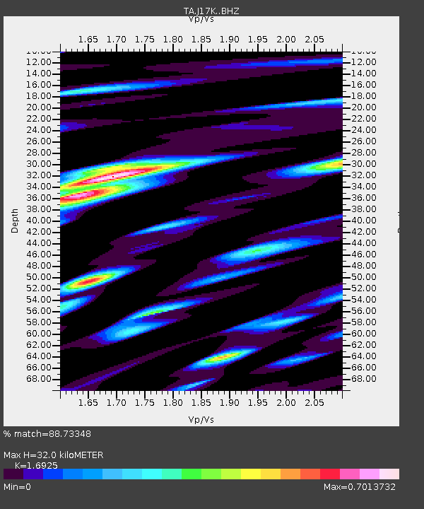
| Estimated Moho Depth: |
32.0 km |
| Estimated Crust Vp/Vs: |
1.69 |
| Assumed Crust Vp: |
6.276 km/s |
| Estimated Crust Vs: |
3.708 km/s |
| Estimated Crust Poisson's Ratio: |
0.23 |
|
| Radial Match: |
88.73348 % |
| Radial Bump: |
400 |
| Transverse Match: |
84.79446 % |
| Transverse Bump: |
400 |
| SOD ConfigId: |
19053131 |
| Insert Time: |
2019-07-22 18:57:07.685 +0000 |
| GWidth: |
2.5 |
| Max Bumps: |
400 |
| Tol: |
0.001 |
|

Signal To Noise
| Channel | StoN | STA | LTA |
| TA:J17K: :BHZ:20190708T19:04:23.025029Z | 14.884482 | 8.0821656E-7 | 5.4299267E-8 |
| TA:J17K: :BHN:20190708T19:04:23.025029Z | 0.8305109 | 5.86489E-8 | 7.061785E-8 |
| TA:J17K: :BHE:20190708T19:04:23.025029Z | 2.537744 | 2.6660155E-7 | 1.05054546E-7 |
| Arrivals |
| Ps | 3.6 SECOND |
| PpPs | 13 SECOND |
| PsPs/PpSs | 17 SECOND |


