You are here: Home > Network List > TA - USArray Transportable Network (new EarthScope stations) Stations List
> Station M19K Big River Lodge, Big River, AK, USA > Earthquake Result Viewer
M19K Big River Lodge, Big River, AK, USA - Earthquake Result Viewer
| Earthquake location: |
Northern Molucca Sea |
| Earthquake latitude/longitude: |
0.5/126.3 |
| Earthquake time(UTC): |
2019/07/08 (189) 18:52:33 GMT |
| Earthquake Depth: |
28 km |
| Earthquake Magnitude: |
5.9 Mww |
| Earthquake Catalog/Contributor: |
NEIC PDE/us |
|
| Network: |
TA USArray Transportable Network (new EarthScope stations) |
| Station: |
M19K Big River Lodge, Big River, AK, USA |
| Lat/Lon: |
61.90 N/154.39 W |
| Elevation: |
521 m |
|
| Distance: |
84.5 deg |
| Az: |
27.861 deg |
| Baz: |
260.786 deg |
| Ray Param: |
0.04538144 |
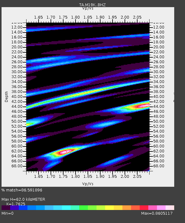
| Estimated Moho Depth: |
62.0 km |
| Estimated Crust Vp/Vs: |
1.76 |
| Assumed Crust Vp: |
6.566 km/s |
| Estimated Crust Vs: |
3.725 km/s |
| Estimated Crust Poisson's Ratio: |
0.26 |
|
| Radial Match: |
86.591896 % |
| Radial Bump: |
400 |
| Transverse Match: |
79.513916 % |
| Transverse Bump: |
400 |
| SOD ConfigId: |
19053131 |
| Insert Time: |
2019-07-22 18:57:23.445 +0000 |
| GWidth: |
2.5 |
| Max Bumps: |
400 |
| Tol: |
0.001 |
|

Signal To Noise
| Channel | StoN | STA | LTA |
| TA:M19K: :BHZ:20190708T19:04:32.34998Z | 6.368652 | 5.8510096E-7 | 9.1872025E-8 |
| TA:M19K: :BHN:20190708T19:04:32.34998Z | 0.68712604 | 6.545768E-8 | 9.526298E-8 |
| TA:M19K: :BHE:20190708T19:04:32.34998Z | 4.008335 | 2.0693876E-7 | 5.1627108E-8 |
| Arrivals |
| Ps | 7.4 SECOND |
| PpPs | 25 SECOND |
| PsPs/PpSs | 33 SECOND |


