You are here: Home > Network List > TA - USArray Transportable Network (new EarthScope stations) Stations List
> Station O16K Kokwok River, Bristol Bay, AK, USA > Earthquake Result Viewer
O16K Kokwok River, Bristol Bay, AK, USA - Earthquake Result Viewer
| Earthquake location: |
Northern Molucca Sea |
| Earthquake latitude/longitude: |
0.5/126.3 |
| Earthquake time(UTC): |
2019/07/08 (189) 18:52:33 GMT |
| Earthquake Depth: |
28 km |
| Earthquake Magnitude: |
5.9 Mww |
| Earthquake Catalog/Contributor: |
NEIC PDE/us |
|
| Network: |
TA USArray Transportable Network (new EarthScope stations) |
| Station: |
O16K Kokwok River, Bristol Bay, AK, USA |
| Lat/Lon: |
59.59 N/158.09 W |
| Elevation: |
198 m |
|
| Distance: |
82.3 deg |
| Az: |
29.812 deg |
| Baz: |
257.784 deg |
| Ray Param: |
0.04693854 |
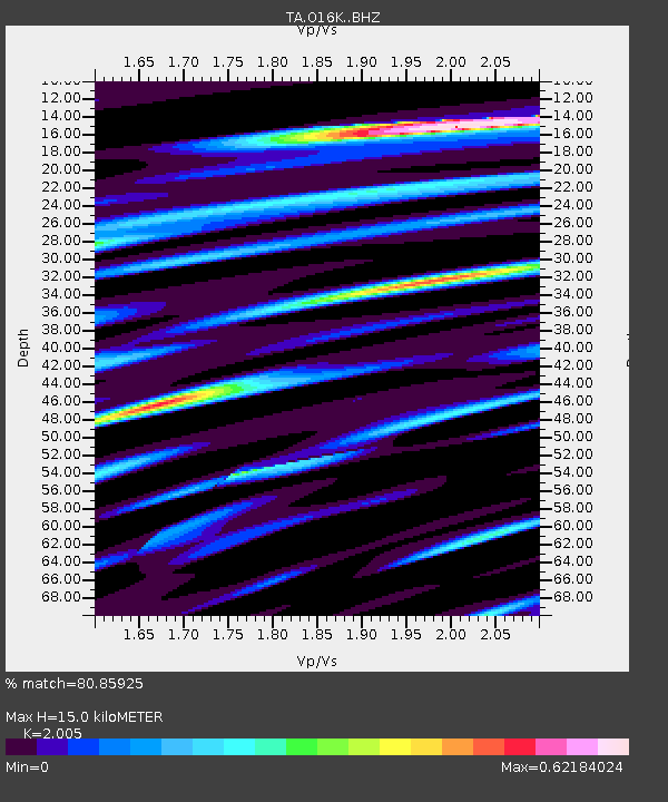
| Estimated Moho Depth: |
15.0 km |
| Estimated Crust Vp/Vs: |
2.01 |
| Assumed Crust Vp: |
6.24 km/s |
| Estimated Crust Vs: |
3.112 km/s |
| Estimated Crust Poisson's Ratio: |
0.33 |
|
| Radial Match: |
80.85925 % |
| Radial Bump: |
400 |
| Transverse Match: |
77.039375 % |
| Transverse Bump: |
392 |
| SOD ConfigId: |
19053131 |
| Insert Time: |
2019-07-22 18:57:34.704 +0000 |
| GWidth: |
2.5 |
| Max Bumps: |
400 |
| Tol: |
0.001 |
|

Signal To Noise
| Channel | StoN | STA | LTA |
| TA:O16K: :BHZ:20190708T19:04:21.000004Z | 10.61376 | 7.3887696E-7 | 6.9615005E-8 |
| TA:O16K: :BHN:20190708T19:04:21.000004Z | 2.4131505 | 1.6169511E-7 | 6.700581E-8 |
| TA:O16K: :BHE:20190708T19:04:21.000004Z | 2.182166 | 2.3066823E-7 | 1.0570609E-7 |
| Arrivals |
| Ps | 2.5 SECOND |
| PpPs | 7.1 SECOND |
| PsPs/PpSs | 9.5 SECOND |


