You are here: Home > Network List > TA - USArray Transportable Network (new EarthScope stations) Stations List
> Station P16K Nushagak River, AK, USA > Earthquake Result Viewer
P16K Nushagak River, AK, USA - Earthquake Result Viewer
| Earthquake location: |
Northern Molucca Sea |
| Earthquake latitude/longitude: |
0.5/126.3 |
| Earthquake time(UTC): |
2019/07/08 (189) 18:52:33 GMT |
| Earthquake Depth: |
28 km |
| Earthquake Magnitude: |
5.9 Mww |
| Earthquake Catalog/Contributor: |
NEIC PDE/us |
|
| Network: |
TA USArray Transportable Network (new EarthScope stations) |
| Station: |
P16K Nushagak River, AK, USA |
| Lat/Lon: |
59.03 N/157.99 W |
| Elevation: |
86 m |
|
| Distance: |
82.2 deg |
| Az: |
30.38 deg |
| Baz: |
257.948 deg |
| Ray Param: |
0.046985045 |
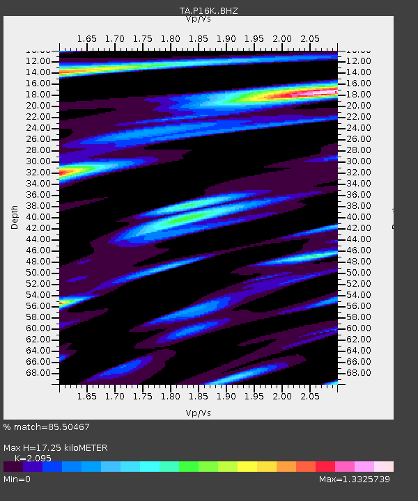
| Estimated Moho Depth: |
17.25 km |
| Estimated Crust Vp/Vs: |
2.10 |
| Assumed Crust Vp: |
6.276 km/s |
| Estimated Crust Vs: |
2.996 km/s |
| Estimated Crust Poisson's Ratio: |
0.35 |
|
| Radial Match: |
85.50467 % |
| Radial Bump: |
400 |
| Transverse Match: |
92.80863 % |
| Transverse Bump: |
400 |
| SOD ConfigId: |
19053131 |
| Insert Time: |
2019-07-22 18:57:38.892 +0000 |
| GWidth: |
2.5 |
| Max Bumps: |
400 |
| Tol: |
0.001 |
|

Signal To Noise
| Channel | StoN | STA | LTA |
| TA:P16K: :BHZ:20190708T19:04:20.650029Z | 9.288228 | 1.2519463E-6 | 1.347885E-7 |
| TA:P16K: :BHN:20190708T19:04:20.650029Z | 1.342132 | 2.7174858E-7 | 2.0247529E-7 |
| TA:P16K: :BHE:20190708T19:04:20.650029Z | 1.8135326 | 3.7236921E-7 | 2.053281E-7 |
| Arrivals |
| Ps | 3.1 SECOND |
| PpPs | 8.3 SECOND |
| PsPs/PpSs | 11 SECOND |


