You are here: Home > Network List > IU - Global Seismograph Network (GSN - IRIS/USGS) Stations List
> Station POHA Pohakuloa, Hawaii, USA > Earthquake Result Viewer
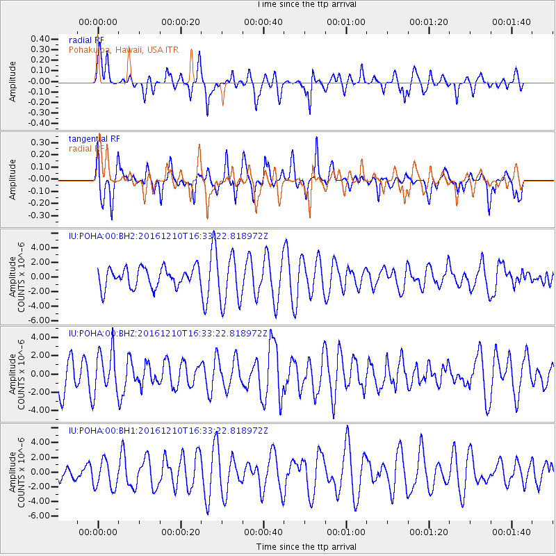
POHA Pohakuloa, Hawaii, USA - Earthquake Result Viewer
*The percent match for this event was below the threshold and hence no stack was calculated.
| Earthquake location: |
Solomon Islands |
| Earthquake latitude/longitude: |
-5.7/154.5 |
| Earthquake time(UTC): |
2016/12/10 (345) 16:24:36 GMT |
| Earthquake Depth: |
157 km |
| Earthquake Magnitude: |
6.1 Mwp |
| Earthquake Catalog/Contributor: |
NEIC PDE/us |
|
| Network: |
IU Global Seismograph Network (GSN - IRIS/USGS) |
| Station: |
POHA Pohakuloa, Hawaii, USA |
| Lat/Lon: |
19.76 N/155.53 W |
| Elevation: |
1990 m |
|
| Distance: |
55.3 deg |
| Az: |
61.37 deg |
| Baz: |
248.039 deg |
| Ray Param: |
$rayparam |
*The percent match for this event was below the threshold and hence was not used in the summary stack. |
|
| Radial Match: |
58.28588 % |
| Radial Bump: |
400 |
| Transverse Match: |
63.52473 % |
| Transverse Bump: |
400 |
| SOD ConfigId: |
1894071 |
| Insert Time: |
2016-12-24 16:28:51.553 +0000 |
| GWidth: |
2.5 |
| Max Bumps: |
400 |
| Tol: |
0.001 |
|
Signal To Noise
| Channel | StoN | STA | LTA |
| IU:POHA:00:BHZ:20161210T16:33:22.818972Z | 1.0075759 | 2.2065633E-6 | 2.1899725E-6 |
| IU:POHA:00:BH1:20161210T16:33:22.818972Z | 1.237003 | 1.9058715E-6 | 1.5407171E-6 |
| IU:POHA:00:BH2:20161210T16:33:22.818972Z | 2.4634593 | 3.2321407E-6 | 1.3120334E-6 |
| Arrivals |
| Ps | |
| PpPs | |
| PsPs/PpSs | |


