You are here: Home > Network List > CN - Canadian National Seismograph Network Stations List
> Station INK INUVIK, NT > Earthquake Result Viewer
INK INUVIK, NT - Earthquake Result Viewer
*The percent match for this event was below the threshold and hence no stack was calculated.
| Earthquake location: |
Sea Of Okhotsk |
| Earthquake latitude/longitude: |
47.4/145.0 |
| Earthquake time(UTC): |
2019/07/09 (190) 11:33:31 GMT |
| Earthquake Depth: |
437 km |
| Earthquake Magnitude: |
5.5 Mww |
| Earthquake Catalog/Contributor: |
NEIC PDE/us |
|
| Network: |
CN Canadian National Seismograph Network |
| Station: |
INK INUVIK, NT |
| Lat/Lon: |
68.31 N/133.53 W |
| Elevation: |
44 m |
|
| Distance: |
44.0 deg |
| Az: |
31.944 deg |
| Baz: |
284.928 deg |
| Ray Param: |
$rayparam |
*The percent match for this event was below the threshold and hence was not used in the summary stack. |
|
| Radial Match: |
75.66653 % |
| Radial Bump: |
400 |
| Transverse Match: |
58.785755 % |
| Transverse Bump: |
400 |
| SOD ConfigId: |
19053131 |
| Insert Time: |
2019-07-23 11:38:01.572 +0000 |
| GWidth: |
2.5 |
| Max Bumps: |
400 |
| Tol: |
0.001 |
|
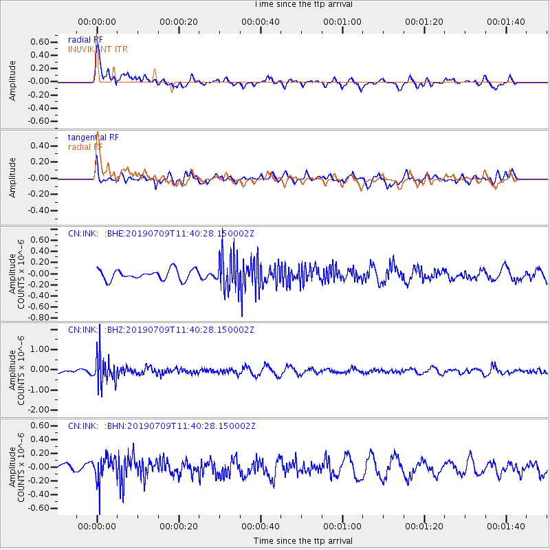
Signal To Noise
| Channel | StoN | STA | LTA |
| CN:INK: :BHZ:20190709T11:40:28.150002Z | 5.6317444 | 6.4796126E-7 | 1.15055165E-7 |
| CN:INK: :BHN:20190709T11:40:28.150002Z | 1.3769854 | 1.6902884E-7 | 1.2275281E-7 |
| CN:INK: :BHE:20190709T11:40:28.150002Z | 3.3586717 | 3.0411638E-7 | 9.0546635E-8 |
| Arrivals |
| Ps | |
| PpPs | |
| PsPs/PpSs | |


