You are here: Home > Network List > US - United States National Seismic Network Stations List
> Station WUAZ Wupatki, Arizona, USA > Earthquake Result Viewer
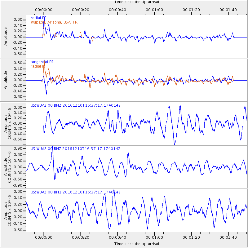
WUAZ Wupatki, Arizona, USA - Earthquake Result Viewer
*The percent match for this event was below the threshold and hence no stack was calculated.
| Earthquake location: |
Solomon Islands |
| Earthquake latitude/longitude: |
-5.7/154.5 |
| Earthquake time(UTC): |
2016/12/10 (345) 16:24:36 GMT |
| Earthquake Depth: |
157 km |
| Earthquake Magnitude: |
6.1 Mwp |
| Earthquake Catalog/Contributor: |
NEIC PDE/us |
|
| Network: |
US United States National Seismic Network |
| Station: |
WUAZ Wupatki, Arizona, USA |
| Lat/Lon: |
35.52 N/111.37 W |
| Elevation: |
1592 m |
|
| Distance: |
96.6 deg |
| Az: |
54.996 deg |
| Baz: |
267.785 deg |
| Ray Param: |
$rayparam |
*The percent match for this event was below the threshold and hence was not used in the summary stack. |
|
| Radial Match: |
60.38723 % |
| Radial Bump: |
400 |
| Transverse Match: |
50.606976 % |
| Transverse Bump: |
390 |
| SOD ConfigId: |
1894071 |
| Insert Time: |
2016-12-24 16:29:37.454 +0000 |
| GWidth: |
2.5 |
| Max Bumps: |
400 |
| Tol: |
0.001 |
|
Signal To Noise
| Channel | StoN | STA | LTA |
| US:WUAZ:00:BHZ:20161210T16:37:17.174014Z | 2.7460678 | 3.368834E-7 | 1.2267847E-7 |
| US:WUAZ:00:BH1:20161210T16:37:17.174014Z | 0.7580947 | 1.3416084E-7 | 1.7697108E-7 |
| US:WUAZ:00:BH2:20161210T16:37:17.174014Z | 1.1171974 | 1.8607825E-7 | 1.6655807E-7 |
| Arrivals |
| Ps | |
| PpPs | |
| PsPs/PpSs | |


