You are here: Home > Network List > GS - US Geological Survey Networks Stations List
> Station DEC09 Decatur Surface Seismic Site, Decatur, IL, USA > Earthquake Result Viewer
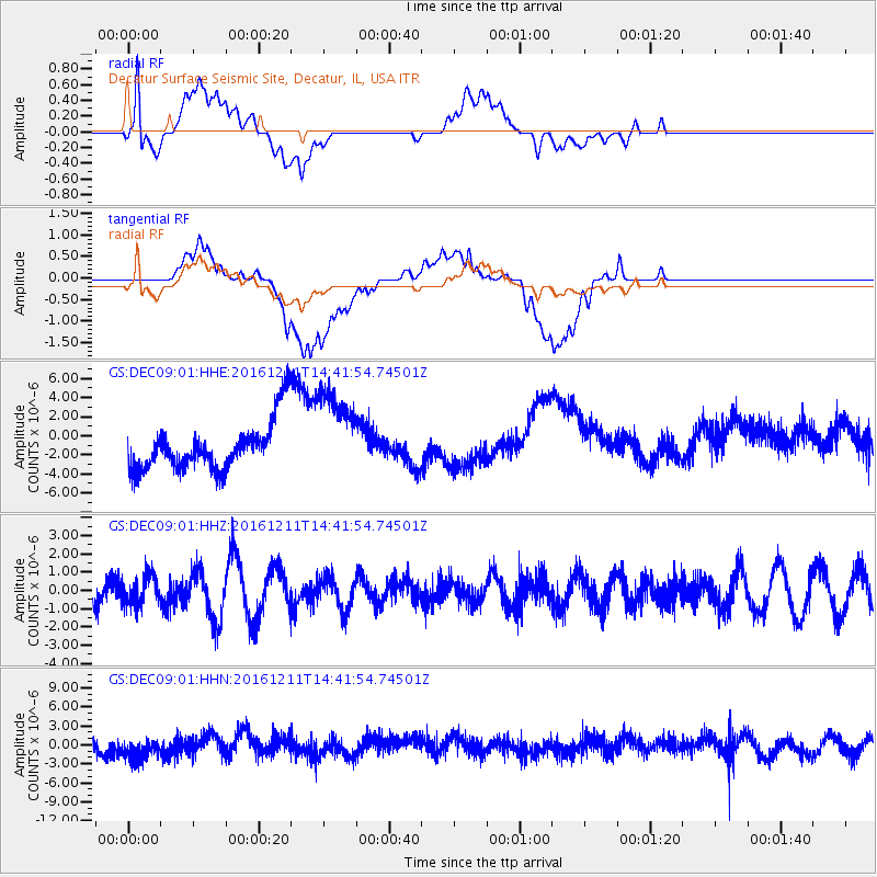
DEC09 Decatur Surface Seismic Site, Decatur, IL, USA - Earthquake Result Viewer
*The percent match for this event was below the threshold and hence no stack was calculated.
| Earthquake location: |
Central East Pacific Rise |
| Earthquake latitude/longitude: |
-9.1/-109.8 |
| Earthquake time(UTC): |
2016/12/11 (346) 14:33:12 GMT |
| Earthquake Depth: |
10 km |
| Earthquake Magnitude: |
5.7 Mwb |
| Earthquake Catalog/Contributor: |
NEIC PDE/us |
|
| Network: |
GS US Geological Survey Networks |
| Station: |
DEC09 Decatur Surface Seismic Site, Decatur, IL, USA |
| Lat/Lon: |
39.87 N/88.92 W |
| Elevation: |
207 m |
|
| Distance: |
52.5 deg |
| Az: |
20.275 deg |
| Baz: |
206.401 deg |
| Ray Param: |
$rayparam |
*The percent match for this event was below the threshold and hence was not used in the summary stack. |
|
| Radial Match: |
65.45644 % |
| Radial Bump: |
400 |
| Transverse Match: |
45.66482 % |
| Transverse Bump: |
400 |
| SOD ConfigId: |
1894071 |
| Insert Time: |
2016-12-25 14:34:26.310 +0000 |
| GWidth: |
2.5 |
| Max Bumps: |
400 |
| Tol: |
0.001 |
|
Signal To Noise
| Channel | StoN | STA | LTA |
| GS:DEC09:01:HHZ:20161211T14:41:54.74501Z | 0.9559645 | 8.101686E-7 | 8.474882E-7 |
| GS:DEC09:01:HHN:20161211T14:41:54.74501Z | 1.4935595 | 2.0242292E-6 | 1.3553054E-6 |
| GS:DEC09:01:HHE:20161211T14:41:54.74501Z | 1.8464311 | 4.729155E-6 | 2.5612412E-6 |
| Arrivals |
| Ps | |
| PpPs | |
| PsPs/PpSs | |


