You are here: Home > Network List > TA - USArray Transportable Network (new EarthScope stations) Stations List
> Station A21K Barrow, AK, USA > Earthquake Result Viewer
A21K Barrow, AK, USA - Earthquake Result Viewer
| Earthquake location: |
Sea Of Okhotsk |
| Earthquake latitude/longitude: |
47.4/145.0 |
| Earthquake time(UTC): |
2019/07/09 (190) 11:33:31 GMT |
| Earthquake Depth: |
437 km |
| Earthquake Magnitude: |
5.5 Mww |
| Earthquake Catalog/Contributor: |
NEIC PDE/us |
|
| Network: |
TA USArray Transportable Network (new EarthScope stations) |
| Station: |
A21K Barrow, AK, USA |
| Lat/Lon: |
71.32 N/156.62 W |
| Elevation: |
577 m |
|
| Distance: |
35.9 deg |
| Az: |
27.869 deg |
| Baz: |
260.098 deg |
| Ray Param: |
0.07501256 |
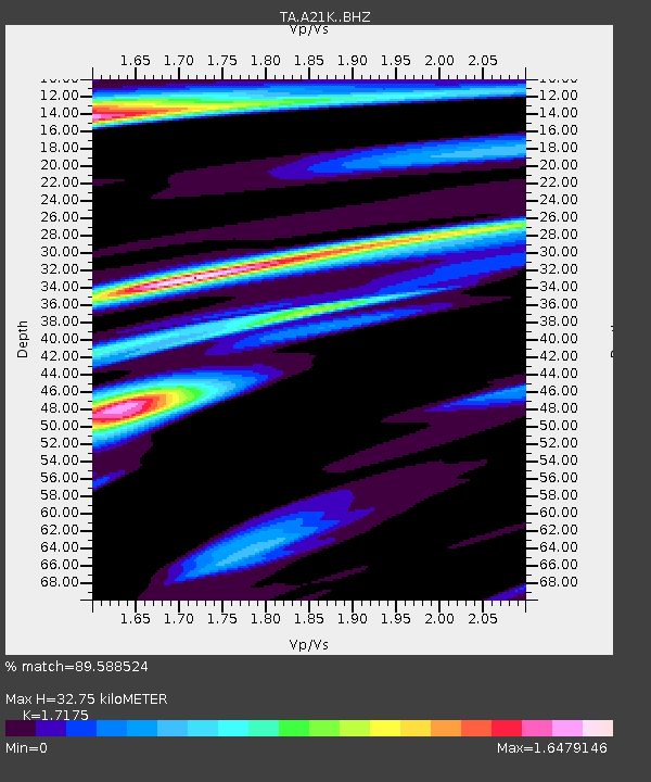
| Estimated Moho Depth: |
32.75 km |
| Estimated Crust Vp/Vs: |
1.72 |
| Assumed Crust Vp: |
6.048 km/s |
| Estimated Crust Vs: |
3.521 km/s |
| Estimated Crust Poisson's Ratio: |
0.24 |
|
| Radial Match: |
89.588524 % |
| Radial Bump: |
400 |
| Transverse Match: |
65.098816 % |
| Transverse Bump: |
400 |
| SOD ConfigId: |
19053131 |
| Insert Time: |
2019-07-23 11:43:12.917 +0000 |
| GWidth: |
2.5 |
| Max Bumps: |
400 |
| Tol: |
0.001 |
|

Signal To Noise
| Channel | StoN | STA | LTA |
| TA:A21K: :BHZ:20190709T11:39:22.850014Z | 28.900366 | 2.6585249E-6 | 9.1989314E-8 |
| TA:A21K: :BHN:20190709T11:39:22.850014Z | 22.38641 | 1.3932256E-6 | 6.223533E-8 |
| TA:A21K: :BHE:20190709T11:39:22.850014Z | 15.855413 | 1.3840778E-6 | 8.729371E-8 |
| Arrivals |
| Ps | 4.1 SECOND |
| PpPs | 14 SECOND |
| PsPs/PpSs | 18 SECOND |


