You are here: Home > Network List > IU - Global Seismograph Network (GSN - IRIS/USGS) Stations List
> Station POHA Pohakuloa, Hawaii, USA > Earthquake Result Viewer
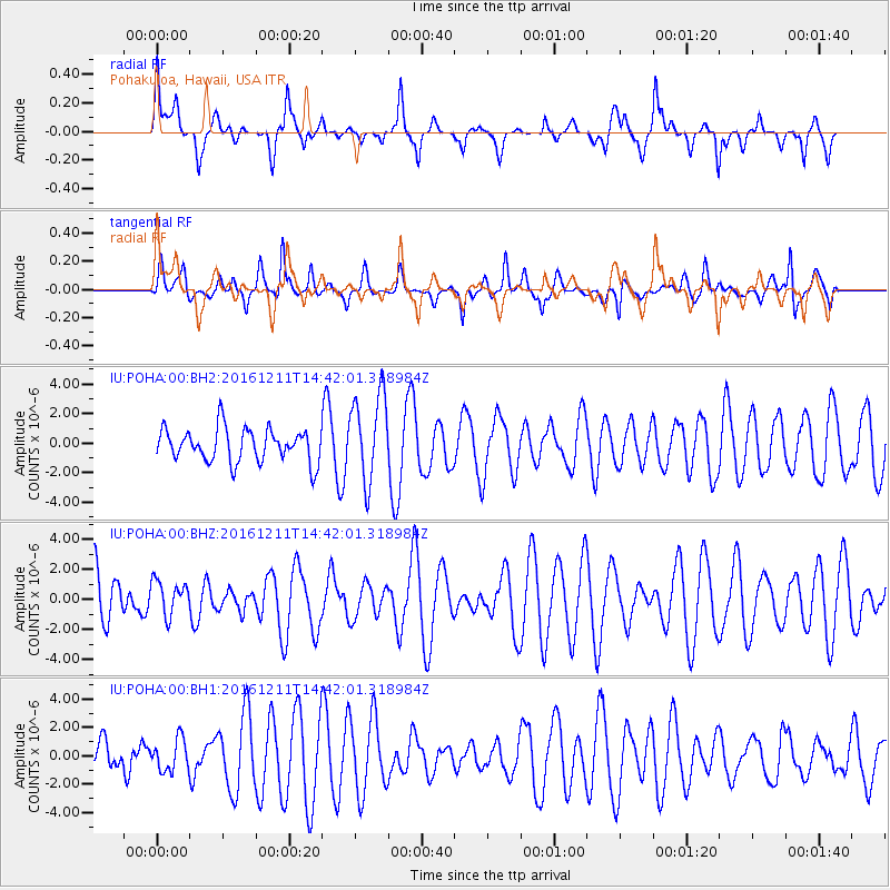
POHA Pohakuloa, Hawaii, USA - Earthquake Result Viewer
*The percent match for this event was below the threshold and hence no stack was calculated.
| Earthquake location: |
Central East Pacific Rise |
| Earthquake latitude/longitude: |
-9.1/-109.8 |
| Earthquake time(UTC): |
2016/12/11 (346) 14:33:12 GMT |
| Earthquake Depth: |
10 km |
| Earthquake Magnitude: |
5.7 Mwb |
| Earthquake Catalog/Contributor: |
NEIC PDE/us |
|
| Network: |
IU Global Seismograph Network (GSN - IRIS/USGS) |
| Station: |
POHA Pohakuloa, Hawaii, USA |
| Lat/Lon: |
19.76 N/155.53 W |
| Elevation: |
1990 m |
|
| Distance: |
53.4 deg |
| Az: |
302.875 deg |
| Baz: |
118.29 deg |
| Ray Param: |
$rayparam |
*The percent match for this event was below the threshold and hence was not used in the summary stack. |
|
| Radial Match: |
55.156883 % |
| Radial Bump: |
400 |
| Transverse Match: |
43.248817 % |
| Transverse Bump: |
324 |
| SOD ConfigId: |
1894071 |
| Insert Time: |
2016-12-25 14:35:09.229 +0000 |
| GWidth: |
2.5 |
| Max Bumps: |
400 |
| Tol: |
0.001 |
|
Signal To Noise
| Channel | StoN | STA | LTA |
| IU:POHA:00:BHZ:20161211T14:42:01.318984Z | 0.58966315 | 1.1457788E-6 | 1.9431072E-6 |
| IU:POHA:00:BH1:20161211T14:42:01.318984Z | 0.30080152 | 1.1127969E-6 | 3.699439E-6 |
| IU:POHA:00:BH2:20161211T14:42:01.318984Z | 2.645804 | 2.9644414E-6 | 1.1204312E-6 |
| Arrivals |
| Ps | |
| PpPs | |
| PsPs/PpSs | |


