You are here: Home > Network List > TA - USArray Transportable Network (new EarthScope stations) Stations List
> Station F21K Alatna River, AK, USA > Earthquake Result Viewer
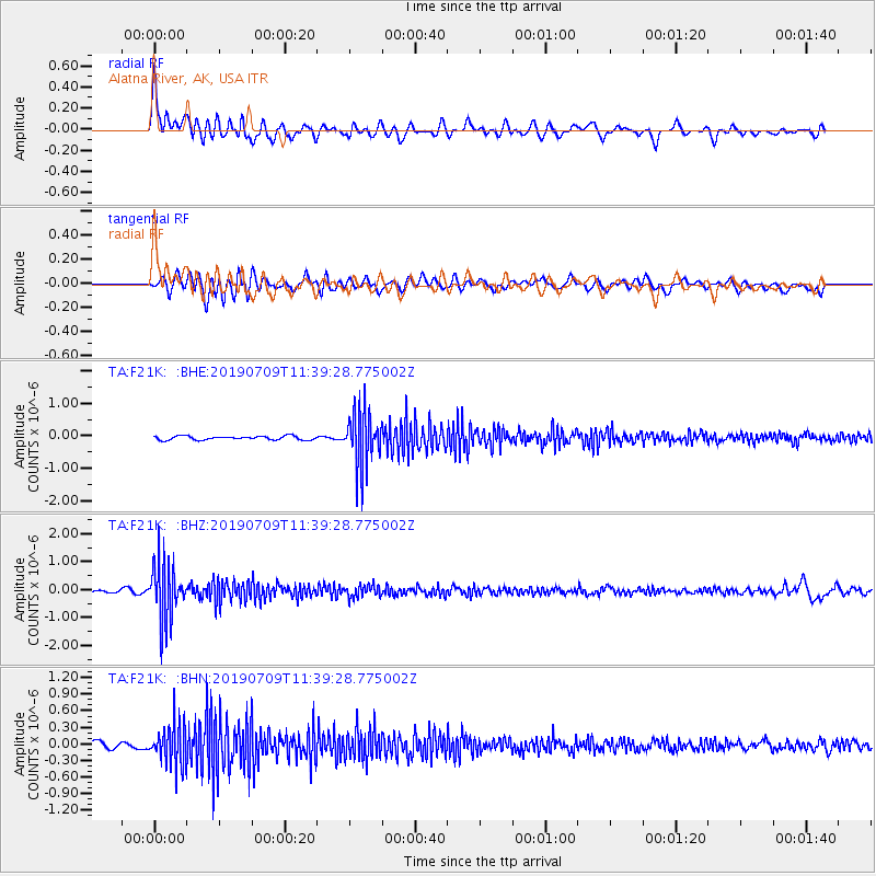
F21K Alatna River, AK, USA - Earthquake Result Viewer
*The percent match for this event was below the threshold and hence no stack was calculated.
| Earthquake location: |
Sea Of Okhotsk |
| Earthquake latitude/longitude: |
47.4/145.0 |
| Earthquake time(UTC): |
2019/07/09 (190) 11:33:31 GMT |
| Earthquake Depth: |
437 km |
| Earthquake Magnitude: |
5.5 Mww |
| Earthquake Catalog/Contributor: |
NEIC PDE/us |
|
| Network: |
TA USArray Transportable Network (new EarthScope stations) |
| Station: |
F21K Alatna River, AK, USA |
| Lat/Lon: |
67.22 N/153.48 W |
| Elevation: |
597 m |
|
| Distance: |
36.6 deg |
| Az: |
34.984 deg |
| Baz: |
268.767 deg |
| Ray Param: |
$rayparam |
*The percent match for this event was below the threshold and hence was not used in the summary stack. |
|
| Radial Match: |
68.98081 % |
| Radial Bump: |
400 |
| Transverse Match: |
53.91059 % |
| Transverse Bump: |
400 |
| SOD ConfigId: |
19053131 |
| Insert Time: |
2019-07-23 11:43:36.656 +0000 |
| GWidth: |
2.5 |
| Max Bumps: |
400 |
| Tol: |
0.001 |
|
Signal To Noise
| Channel | StoN | STA | LTA |
| TA:F21K: :BHZ:20190709T11:39:28.775002Z | 20.25848 | 1.0377057E-6 | 5.1223275E-8 |
| TA:F21K: :BHN:20190709T11:39:28.775002Z | 6.886754 | 3.4519982E-7 | 5.0125184E-8 |
| TA:F21K: :BHE:20190709T11:39:28.775002Z | 13.999656 | 8.204616E-7 | 5.8605842E-8 |
| Arrivals |
| Ps | |
| PpPs | |
| PsPs/PpSs | |


