You are here: Home > Network List > TA - USArray Transportable Network (new EarthScope stations) Stations List
> Station M04C Macdoel, CA, USA > Earthquake Result Viewer
M04C Macdoel, CA, USA - Earthquake Result Viewer
| Earthquake location: |
Near Coast Of Peru |
| Earthquake latitude/longitude: |
-13.6/-76.6 |
| Earthquake time(UTC): |
2007/08/19 (231) 01:22:40 GMT |
| Earthquake Depth: |
26 km |
| Earthquake Magnitude: |
5.9 MB, 5.4 MS, 5.8 MW, 5.5 ML |
| Earthquake Catalog/Contributor: |
WHDF/NEIC |
|
| Network: |
TA USArray Transportable Network (new EarthScope stations) |
| Station: |
M04C Macdoel, CA, USA |
| Lat/Lon: |
41.78 N/121.84 W |
| Elevation: |
1391 m |
|
| Distance: |
69.1 deg |
| Az: |
325.369 deg |
| Baz: |
132.376 deg |
| Ray Param: |
0.05583575 |
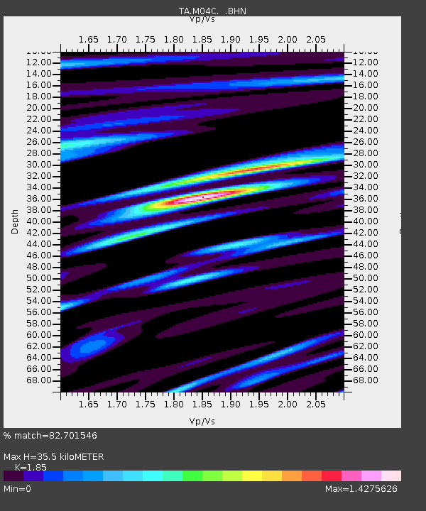
| Estimated Moho Depth: |
35.5 km |
| Estimated Crust Vp/Vs: |
1.85 |
| Assumed Crust Vp: |
6.566 km/s |
| Estimated Crust Vs: |
3.549 km/s |
| Estimated Crust Poisson's Ratio: |
0.29 |
|
| Radial Match: |
82.701546 % |
| Radial Bump: |
400 |
| Transverse Match: |
75.71346 % |
| Transverse Bump: |
400 |
| SOD ConfigId: |
2564 |
| Insert Time: |
2010-03-07 01:29:46.504 +0000 |
| GWidth: |
2.5 |
| Max Bumps: |
400 |
| Tol: |
0.001 |
|

Signal To Noise
| Channel | StoN | STA | LTA |
| TA:M04C: :BHN:20070819T01:33:13.250027Z | 0.84562534 | 1.257944E-7 | 1.4875903E-7 |
| TA:M04C: :BHE:20070819T01:33:13.250027Z | 2.0276906 | 2.3738224E-7 | 1.1707025E-7 |
| TA:M04C: :BHZ:20070819T01:33:13.250027Z | 5.532109 | 4.985178E-7 | 9.0113524E-8 |
| Arrivals |
| Ps | 4.8 SECOND |
| PpPs | 15 SECOND |
| PsPs/PpSs | 20 SECOND |


