You are here: Home > Network List > TA - USArray Transportable Network (new EarthScope stations) Stations List
> Station G31M Satah River, YT, CAN > Earthquake Result Viewer
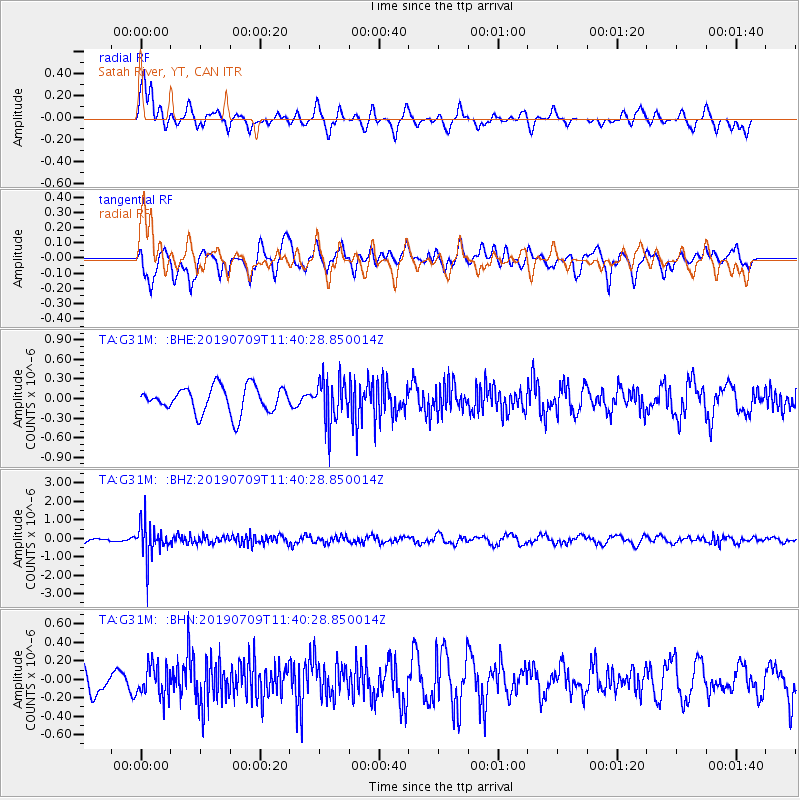
G31M Satah River, YT, CAN - Earthquake Result Viewer
*The percent match for this event was below the threshold and hence no stack was calculated.
| Earthquake location: |
Sea Of Okhotsk |
| Earthquake latitude/longitude: |
47.4/145.0 |
| Earthquake time(UTC): |
2019/07/09 (190) 11:33:31 GMT |
| Earthquake Depth: |
437 km |
| Earthquake Magnitude: |
5.5 Mww |
| Earthquake Catalog/Contributor: |
NEIC PDE/us |
|
| Network: |
TA USArray Transportable Network (new EarthScope stations) |
| Station: |
G31M Satah River, YT, CAN |
| Lat/Lon: |
66.92 N/134.27 W |
| Elevation: |
61 m |
|
| Distance: |
44.1 deg |
| Az: |
33.981 deg |
| Baz: |
285.704 deg |
| Ray Param: |
$rayparam |
*The percent match for this event was below the threshold and hence was not used in the summary stack. |
|
| Radial Match: |
64.08222 % |
| Radial Bump: |
400 |
| Transverse Match: |
63.489426 % |
| Transverse Bump: |
400 |
| SOD ConfigId: |
19053131 |
| Insert Time: |
2019-07-23 11:43:48.154 +0000 |
| GWidth: |
2.5 |
| Max Bumps: |
400 |
| Tol: |
0.001 |
|
Signal To Noise
| Channel | StoN | STA | LTA |
| TA:G31M: :BHZ:20190709T11:40:28.850014Z | 5.0446553 | 9.5129184E-7 | 1.8857419E-7 |
| TA:G31M: :BHN:20190709T11:40:28.850014Z | 1.3106515 | 1.7366892E-7 | 1.3250579E-7 |
| TA:G31M: :BHE:20190709T11:40:28.850014Z | 1.6697441 | 3.3294208E-7 | 1.9939706E-7 |
| Arrivals |
| Ps | |
| PpPs | |
| PsPs/PpSs | |


