You are here: Home > Network List > TA - USArray Transportable Network (new EarthScope stations) Stations List
> Station M04C Macdoel, CA, USA > Earthquake Result Viewer
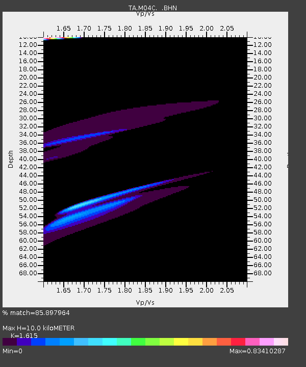
M04C Macdoel, CA, USA - Earthquake Result Viewer
| Earthquake location: |
Solomon Islands |
| Earthquake latitude/longitude: |
-7.3/155.6 |
| Earthquake time(UTC): |
2007/04/01 (091) 21:45:37 GMT |
| Earthquake Depth: |
10 km |
| Earthquake Magnitude: |
5.7 MB |
| Earthquake Catalog/Contributor: |
WHDF/NEIC |
|
| Network: |
TA USArray Transportable Network (new EarthScope stations) |
| Station: |
M04C Macdoel, CA, USA |
| Lat/Lon: |
41.78 N/121.84 W |
| Elevation: |
1391 m |
|
| Distance: |
89.3 deg |
| Az: |
47.866 deg |
| Baz: |
259.598 deg |
| Ray Param: |
0.04196336 |
| Estimated Moho Depth: |
10.0 km |
| Estimated Crust Vp/Vs: |
1.62 |
| Assumed Crust Vp: |
6.566 km/s |
| Estimated Crust Vs: |
4.066 km/s |
| Estimated Crust Poisson's Ratio: |
0.19 |
|
| Radial Match: |
85.897964 % |
| Radial Bump: |
400 |
| Transverse Match: |
82.55404 % |
| Transverse Bump: |
400 |
| SOD ConfigId: |
2564 |
| Insert Time: |
2010-03-07 01:30:21.304 +0000 |
| GWidth: |
2.5 |
| Max Bumps: |
400 |
| Tol: |
0.001 |
|

Signal To Noise
| Channel | StoN | STA | LTA |
| TA:M04C: :BHN:20070401T21:58:02.300012Z | 4.0723147 | 1.596228E-5 | 3.9197066E-6 |
| TA:M04C: :BHE:20070401T21:58:02.300012Z | 0.62364894 | 1.902812E-5 | 3.0510948E-5 |
| TA:M04C: :BHZ:20070401T21:58:02.300012Z | 1.026519 | 2.9181678E-5 | 2.8427801E-5 |
| Arrivals |
| Ps | 1.0 SECOND |
| PpPs | 3.9 SECOND |
| PsPs/PpSs | 4.8 SECOND |


