You are here: Home > Network List > TA - USArray Transportable Network (new EarthScope stations) Stations List
> Station P17K Kvichak River, AK, USA > Earthquake Result Viewer
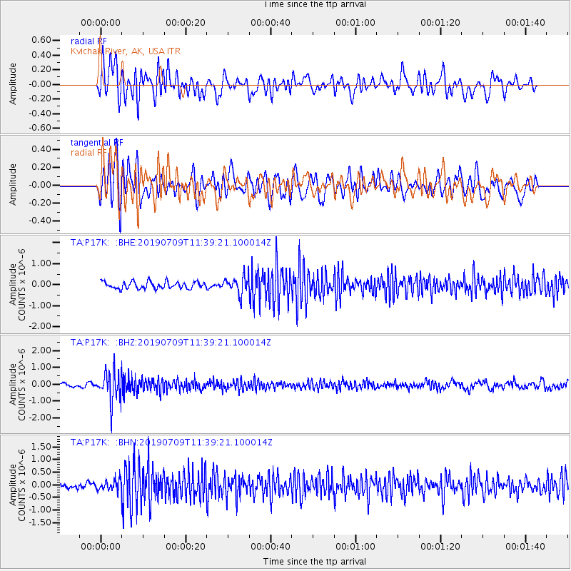
P17K Kvichak River, AK, USA - Earthquake Result Viewer
*The percent match for this event was below the threshold and hence no stack was calculated.
| Earthquake location: |
Sea Of Okhotsk |
| Earthquake latitude/longitude: |
47.4/145.0 |
| Earthquake time(UTC): |
2019/07/09 (190) 11:33:31 GMT |
| Earthquake Depth: |
437 km |
| Earthquake Magnitude: |
5.5 Mww |
| Earthquake Catalog/Contributor: |
NEIC PDE/us |
|
| Network: |
TA USArray Transportable Network (new EarthScope stations) |
| Station: |
P17K Kvichak River, AK, USA |
| Lat/Lon: |
59.20 N/156.44 W |
| Elevation: |
91 m |
|
| Distance: |
35.7 deg |
| Az: |
48.756 deg |
| Baz: |
277.262 deg |
| Ray Param: |
$rayparam |
*The percent match for this event was below the threshold and hence was not used in the summary stack. |
|
| Radial Match: |
66.55776 % |
| Radial Bump: |
400 |
| Transverse Match: |
67.81302 % |
| Transverse Bump: |
400 |
| SOD ConfigId: |
19053131 |
| Insert Time: |
2019-07-23 11:44:39.206 +0000 |
| GWidth: |
2.5 |
| Max Bumps: |
400 |
| Tol: |
0.001 |
|
Signal To Noise
| Channel | StoN | STA | LTA |
| TA:P17K: :BHZ:20190709T11:39:21.100014Z | 9.4013 | 8.675175E-7 | 9.227633E-8 |
| TA:P17K: :BHN:20190709T11:39:21.100014Z | 1.3980421 | 2.0359282E-7 | 1.456271E-7 |
| TA:P17K: :BHE:20190709T11:39:21.100014Z | 2.4969158 | 4.120671E-7 | 1.6503043E-7 |
| Arrivals |
| Ps | |
| PpPs | |
| PsPs/PpSs | |


