You are here: Home > Network List > TA - USArray Transportable Network (new EarthScope stations) Stations List
> Station M04C Macdoel, CA, USA > Earthquake Result Viewer
M04C Macdoel, CA, USA - Earthquake Result Viewer

| Earthquake location: |
Samoa Islands Region |
| Earthquake latitude/longitude: |
-16.6/-172.0 |
| Earthquake time(UTC): |
2006/09/28 (271) 06:22:09 GMT |
| Earthquake Depth: |
28 km |
| Earthquake Magnitude: |
6.5 MB, 6.6 MS, 6.9 MW, 6.7 MW |
| Earthquake Catalog/Contributor: |
WHDF/NEIC |
|
| Network: |
TA USArray Transportable Network (new EarthScope stations) |
| Station: |
M04C Macdoel, CA, USA |
| Lat/Lon: |
41.78 N/121.84 W |
| Elevation: |
1391 m |
|
| Distance: |
74.3 deg |
| Az: |
36.643 deg |
| Baz: |
229.925 deg |
| Ray Param: |
0.05239419 |
| Estimated Moho Depth: |
10.0 km |
| Estimated Crust Vp/Vs: |
1.87 |
| Assumed Crust Vp: |
6.566 km/s |
| Estimated Crust Vs: |
3.507 km/s |
| Estimated Crust Poisson's Ratio: |
0.30 |
|
| Radial Match: |
94.31996 % |
| Radial Bump: |
400 |
| Transverse Match: |
89.41367 % |
| Transverse Bump: |
400 |
| SOD ConfigId: |
2665 |
| Insert Time: |
2010-03-07 01:30:30.111 +0000 |
| GWidth: |
2.5 |
| Max Bumps: |
400 |
| Tol: |
0.001 |
|
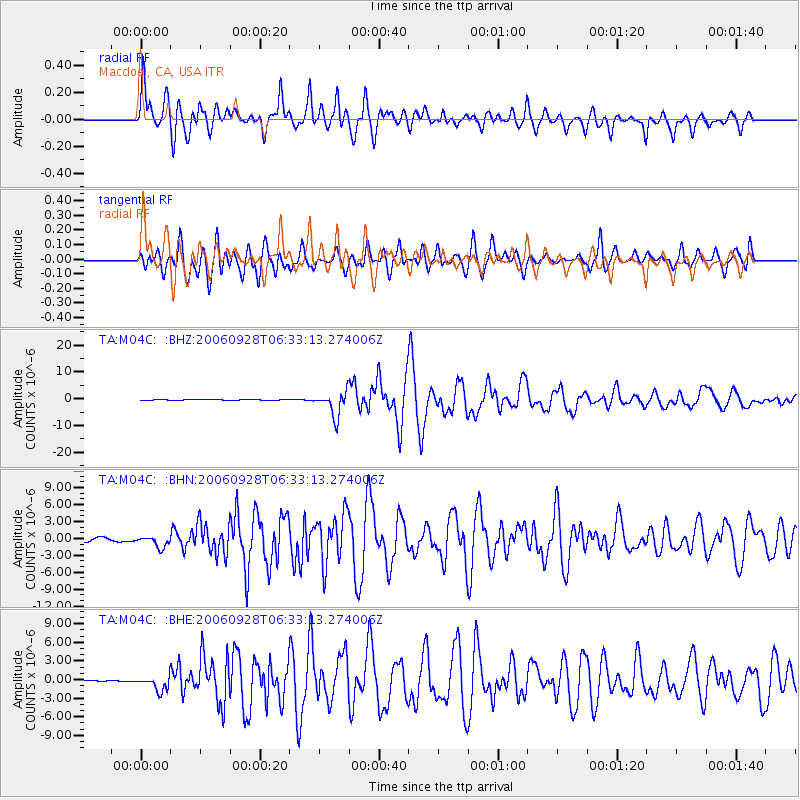
Signal To Noise
| Channel | StoN | STA | LTA |
| TA:M04C: :BHN:20060928T06:33:13.274006Z | 3.074154 | 9.639917E-7 | 3.1357956E-7 |
| TA:M04C: :BHE:20060928T06:33:13.274006Z | 5.8257856 | 1.1665126E-6 | 2.0023266E-7 |
| TA:M04C: :BHZ:20060928T06:33:13.274006Z | 30.982105 | 4.5703127E-6 | 1.475146E-7 |
| Arrivals |
| Ps | 1.4 SECOND |
| PpPs | 4.2 SECOND |
| PsPs/PpSs | 5.6 SECOND |


