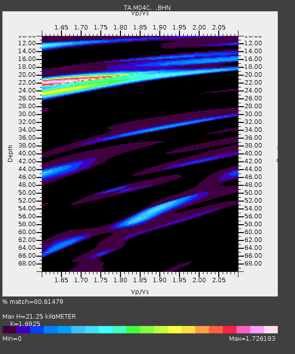
M04C Macdoel, CA, USA - Earthquake Result Viewer
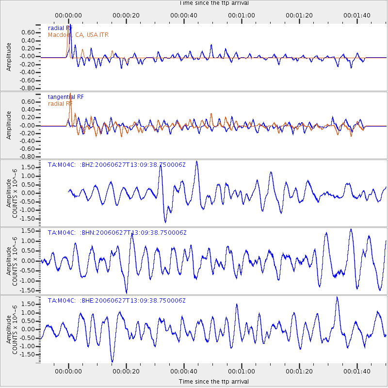
Earthquake location: Off Coast Of Chiapas, Mexico
Earthquake latitude/longitude: 15.0/-94.2
Earthquake time(UTC): 2006/06/27 (178) 13:03:12 GMT
Earthquake Depth: 29 km
Earthquake Magnitude: 5.4 MB, 5.5 MS, 5.8 MW, 5.8 MW
Earthquake Catalog/Contributor: WHDF/NEIC
Network: TA USArray Transportable Network (new EarthScope stations)
Station: M04C Macdoel, CA, USA
Lat/Lon: 41.78 N/121.84 W
Elevation: 1391 m
Distance: 35.9 deg
Az: 323.644 deg
Baz: 129.995 deg
Ray Param: 0.07695088
Estimated Moho Depth: 21.25 km
Estimated Crust Vp/Vs: 1.69
Assumed Crust Vp: 6.566 km/s
Estimated Crust Vs: 3.88 km/s
Estimated Crust Poisson's Ratio: 0.23
Radial Match: 80.61479 %
Radial Bump: 244
Transverse Match: 64.20955 %
Transverse Bump: 388
SOD ConfigId: 2665
Insert Time: 2010-03-07 01:30:41.490 +0000
GWidth: 2.5
Max Bumps: 400
Tol: 0.001

Signal To Noise

ChannelStoNSTALTA
TA:M04C: :BHN:20060627T13:09:38.750006Z2.38555315.00539E-72.0982094E-7
TA:M04C: :BHE:20060627T13:09:38.750006Z1.37008435.172257E-73.7751377E-7
TA:M04C: :BHZ:20060627T13:09:38.750006Z3.069429.605152E-73.129305E-7
Arrivals
Ps2.4 SECOND
PpPs8.0 SECOND
PsPs/PpSs10 SECOND