You are here: Home > Network List > WY - Yellowstone Wyoming Seismic Network Stations List
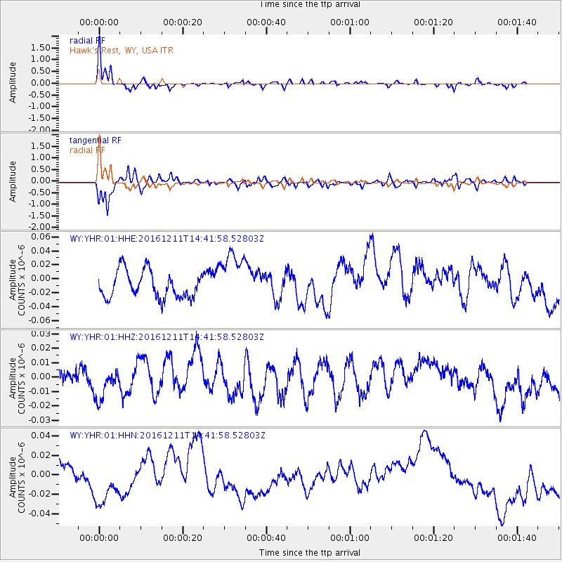
> Station YHR Hawk's Rest, WY, USA > Earthquake Result Viewer
YHR Hawk's Rest, WY, USA - Earthquake Result Viewer
| Earthquake location: |
Central East Pacific Rise |
| Earthquake latitude/longitude: |
-9.1/-109.8 |
| Earthquake time(UTC): |
2016/12/11 (346) 14:33:12 GMT |
| Earthquake Depth: |
10 km |
| Earthquake Magnitude: |
5.7 Mwb |
| Earthquake Catalog/Contributor: |
NEIC PDE/us |
|
| Network: |
WY Yellowstone Wyoming Seismic Network |
| Station: |
YHR Hawk's Rest, WY, USA |
| Lat/Lon: |
44.11 N/110.08 W |
| Elevation: |
2976 m |
|
| Distance: |
53.0 deg |
| Az: |
359.787 deg |
| Baz: |
179.709 deg |
| Ray Param: |
0.06640402 |
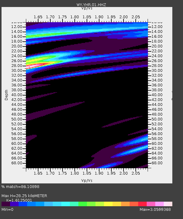
| Estimated Moho Depth: |
28.25 km |
| Estimated Crust Vp/Vs: |
1.61 |
| Assumed Crust Vp: |
6.35 km/s |
| Estimated Crust Vs: |
3.938 km/s |
| Estimated Crust Poisson's Ratio: |
0.19 |
|
| Radial Match: |
86.10898 % |
| Radial Bump: |
335 |
| Transverse Match: |
76.1203 % |
| Transverse Bump: |
400 |
| SOD ConfigId: |
1894071 |
| Insert Time: |
2016-12-25 14:37:32.808 +0000 |
| GWidth: |
2.5 |
| Max Bumps: |
400 |
| Tol: |
0.001 |
|
Signal To Noise
| Channel | StoN | STA | LTA |
| WY:YHR:01:HHZ:20161211T14:41:58.52803Z | 1.3551838 | 1.09278755E-8 | 8.063759E-9 |
| WY:YHR:01:HHN:20161211T14:41:58.52803Z | 1.9685272 | 2.8413773E-8 | 1.4434026E-8 |
| WY:YHR:01:HHE:20161211T14:41:58.52803Z | 2.0142236 | 3.8378833E-8 | 1.9053909E-8 |
| Arrivals |
| Ps | 2.9 SECOND |
| PpPs | 11 SECOND |
| PsPs/PpSs | 14 SECOND |


